PRE2020 3 Group5
Emergency Drone
Group Members
| Name | Student ID | Department | Email address |
|---|---|---|---|
| Pepijn Hundepool | 1427520 | Mechanical Engineering | p.c.j.hundepool@student.tue.nl |
| Lucas Commissaris | 1451065 | Mechanical Engineering | l.f.h.commissaris@student.tue.nl |
| Sven Passier | 1448781 | Mechanical Engineering | s.w.l.passier@student.tue.nl |
| Bram van den Buijs | 1464647 | Applied Physics | b.v.d.buijs@student.tue.nl |
| Stijn Borgers | 1495968 | Applied Physics | s.borgers@student.tue.nl |
Problem statement and objectives
The popularity and usage of compact unmanned aerial vehicles (UAVs), better known as drones, has been increasing radically over the past few years [1]. For only a rather small amount of money, you can already get yourself a drone with some basic abilities. Besides the consumer usage (e.g. hobbyists), the majority of the drone market is represented by military purposes. However, for our project a smaller group is focussed on: Commercial users. This group contains for instance drones with purposes for 3D mapping, delivery, inspections, data transmissions, and video collection. Although this group represents the least percentage of sales of the aforementioned sectors, the revenue value in 2016 was about 60 percent more than the one following from commercial purchases. This phenomenom is mainly caused by the fact that price tags of about $100,000 are no exception in such industries.
A sector that does not really match the term 'comercially' as it regards the type of institution, but does regarding the production price tag are drones used by governmental bodies. In specific it concerns departments that are of key-importance in emergeny situations, with the three most central ones being respectively the police, firefighting and medical (ambulance) departments. In these departments, try-outs and permanent involvements of drones become more and more part of the job [2]. However, since these drones often include high-advanced technologies, their production costs can rise to serious heights. A proper police drone for example lies in the purchasing range from $50,00 to $200,000 [3].
This project aims to develop a new type of drone, which will be able to carry out tasks for more than one of these departments. Roughly sketched, this will result in a drone with a range of standard functions, on which a specific variation of equipment can be (de)attached. This multifunctional drone will have multiple benefits over the development of drones that are specified per department. The most important one, as already indicated in the foregoing, will be the cost-effectiveness. This would for example be benefitial for regions that might lack budget to invest in innovative technologies such as drones, but still strive to develop the implementation of high-tech equipment in their daily work. A second benefit, partially cohesive with the previous one, is that drones can be used more efficiently at for instance an incident or natural disaster, where often more than one department is providing assistance. Since the equipment can be varied for multiple departments, different tasks can be executed with the same drone. As a result, when at a certain moment in time a department is not using their drone(s), other departments can make use of it instead.
(Current version: These will be further elaborated on)
The objectives of our project are to deliver:
- A CAD-design for the emergency drone (with specific materials)
- A FEM-analysis of the designed emergency drone
- Creating a controller (weather conditions and stability)
- Primary user's viewpoint research (to be formulated differently)
To be added sources
[1] https://www.toptal.com/finance/market-research-analysts/drone-market
[2] https://www.politie.nl/nieuws/2020/november/16/00-nieuwe-drones-voor-politietaken.html
[3] https://www.meritalk.com/articles/government-saves-time-money-with-drones/
Sources
Bram: [11] [12] [13] [14] [15]
Stijn: [16] [17] [18] [19] [20]
Pepijn: [21] [22] [23] [24] [25]
User, Society and Enterprise
Users
The primary users of the emergency drones are the civil servants that work in the fire, police and medical department. To be more specific: within the fire department the drone will be used to assist in extinguishing fires and as a fire-reconnaissance tool, within the police department it will be used for surveillance and as a criminal-reconnaissance tool and finally within the medical department the drone will be used for the transport of goods between hospitals and between hospital and civilian who makes the emergency call.
The secondary users are all civilians. Civilians could be trapped inside a burning building, they could be under surveillance, they could be in a hospital with the need for a certain essential good like blood or they could be in need of an AED to revive someone. In all these cases, civilians are on the receiving end of a emergency drone.
Questionnaire
To confirm some of our speculations on the user needs we send out a questionnaire to a variety of stakeholders. We asked a few questions about technical specifications and how drones could be used best. We also asked them about their attitude towards the implementation of drones into their work to confirm the usefulness of our project. To have a more in-depth understanding of certain technical difficulties and choices, we (tried to) interviewed someone from one of the three different sectors.
QUESTIONNAIRSESES
INTERVIEW QUESITONS
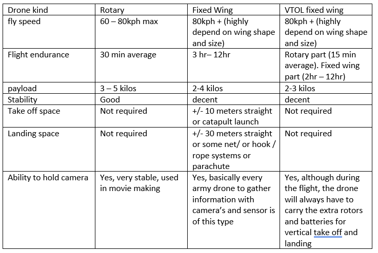
General: Would you like to see drones with a significant different appearance then commercial drones? Would transporting equipment be useful? Which equipment? How much should a drone be able to carry? What type of drone would be useful? a quadcopter, a fixed wing drone, and a hybridcopter (which is a combination of both)? Are there any prerequisites in the specs of the camera? How can your drones be improved? Do you have any other ideas of where a drones could be used to assist you in the sector?
Fire: Drones are not used to extinguish fires. Why? Do you think it is possible? Maybe even autonomously? In which range of fires do you see a drone being deployed? Is it useful to deploy a drone for all types of fire?
Medical: Would it be useful to transport between hospitals using drones? for example blood. or from Sanquin? Would transporting an AED with a drone be useful for emergency calls? (For a person an AED on site within the first minute will have a survival chance of 90%, every minute it will decrease with 7% to 10%) (General question) Would transporting equipment be useful? equipment examples: vaccin organs antidotes first-aid-kit
Police:
Do you see drones being used to do active crowd management?
Would it be useful to have a drones pursue suspects?
Society
There are different stakeholders to be considered for the influence of the society. The government is a major stakeholder, because of the legislation of drones for emergencies usage. Animal rights and environmental organizations have a large interest in maintaining and/or improving the current situation. The drone technology could be dangerous and do damage to society. The flying stakeholder who are using the airspace now must be taken into account, like bird, planes or other drones.
The effect on society would be beneficial on a great scale. (source with death due to cardiac arrest). When drones could deliver an AED within 6 minutes, the survival changes would increase significantly. Other medical usage could be the transport of blood or organs. Not only transport of equipment, but also for investigation for the fire and police departments. All of this would increase the safety and save precious time.
The secondary users, the general people, have according to our questionnaire and other sources …. (safety (own safety, hacking), privacy, noise)
Enterprise
In order to realize emergency drones, the product needs to be produced by a technology company. This company will only build, deliver, and repair these drones. The company will work closely together with a government agency. This agency will be responsible for the usage and quality of the drones, after they have been bought from the drone company. A close cooperation between both stakeholders will lead to an better end product.
Whenever an accident happens due to a drone or due to the usage of an drone, this government agency can be hold responsible. The agency will have to test each drone thoroughly, to limit the risks of accidents. The government agency will also be ultimately responsible for the usage of data gathered by drones. The government agency will have to check at police, medical and fire departments how they deal with the information and data form the drones and if all drone deployment regulations are complied. The relation between the agency and the departments could be seen as principal-agent relationship.
When civilians have an unpleasant experience with the usage of drones by a police, medical or fire department or when they simply feel disturbed by the usage of drones in general, the government agency should be contacted. The agency should write a simply report about each of these complains. The agency should also have the tools to track down the specific drone and flightpath, to see if any regulations on drone deployment where infringed.
State of the Art
Transport drones
Medical drone service
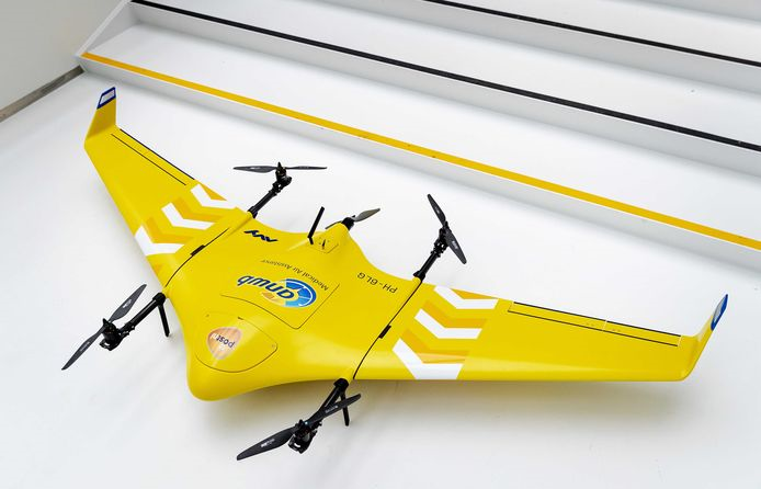
Drone company AVY and several partners are currently testing a long range drone delivery service [1]. The consortium, called Medical Drone Service, will research how the system can impact healthcare in the Netherlands. This consortium consists of several companies, that each have their own expertise; the most important ones are: The ANWB (who are also behind the medical helicopters), PostNL (postal logistics), Erasmus MC (hospital) and Sanquin (blood bank).
During this pilot, a distance of 15 km is travelled in a sparsely populated area, and in the current stadium no medical equipment is yet transported. The main transport is meant to consist out of e.g. medicines, blood and urgent medical deliveries [2].
The drone flies autonomously, but is constantly monitored and at any time the control can be taken over. This specific drone is the AVY Aera, which is also called a Vertical Take Off and Landing wing drone. This term, as you might expect, means that it can take off and land vertically, and subsequently fly horizontally. This can be of great advantage in crowded areas, as the vertical landing makes large landing strips redundant. The drone has a wingspan of 2.5 meters and flies with a speed between the 70 and 80 km/hour, which it can maintain for about an hour. The height it flies at is about 100 meters and at the moment it can only transport a maximum load of 1.5 kilograms. An example of a technical challenge that this drone faces is to maintain a certain temperature, as blood has for instance ideal temperatures at which it should be transported [3]. In addition, it doesn’t fly at bad weather conditions.
To be added sources:
[1] https://www.sbicnoordwijk.nl/avy-medical-drone-service-anwb/
[2] https://www.anwb.nl/nieuws/maa/testvluchten-medisch-transport-per-drone-van-start
[3] https://www.smarthealth.nl/2019/12/12/heeft-drone-delivery-toekomst-in-de-nederlandse-zorg/
Zipline drone network
Blood transport
The American drone company Zipline created the world’s first ever drone delivery network for blood transportation in Rwanda (Africa), in October 2016 [1]. Zipline has distribution centers from where the drones are launched. These centers also perform the function of storage and warehousing of blood and the drones. When a doctor places an order for blood to the distribution center (e.g. through a message or call), workers at Zipline takes the blood from the refrigerator, wraps it with insulated paper and packs it in an insulated cardboard box, after which it is loaded in the drone. Subsequently, the drone takes off to deliver the cargo to one of the clinics.
Zipline uses planes instead of quad copters (which uses four rotors), as quad copters uses far more energy to fly. They can’t manage the range from batteries necessary to travel longer distances and are relatively slow as well. On an average, one delivery is completed in 15-45 minutes and it takes 5-7 minutes to launch the drone after receiving the order. Zipline handles approximately 500 deliveries per day. These drones travel with a speed of 100 km/hour, with a range of over 160 km (allowing the drone an 80 km zone around the location). When the drone reaches the delivery location, it descends to 30 feet to deliver the packet.
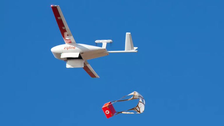
About the physical components of the drone. It has a wingspan of 3 meters and the maximum load it can handle per flight is 1.8 kilograms. The batteries (lithium ion batteries with a total capacity of 1.2 kilowatt hours) are the heaviest part of the aircraft, making up half of the total weight of the aircraft, weighing a total of 10 kilograms.
The drone has a few specifics that are worth mentioning. Instead of a regular GPS circuit, a detachable battery is used in which a GPS is present. This was done as the regular one experienced delay when connecting to the satellite. Another point is the fact that the cargo is dropped with a little parachute. As a result, the clinic at which it is delivered does not require any additional infrastructure to land the drone, and the drone can immediately return to the distribution center. The landing system for the drone is impressive and complicated at the same time. At the distribution center, two actuated arms are located, between which a wire is strung. The drone flies towards the arms, which catch a hook attached to the drone, and brake and end the drone’s flight.

Vaccine transport
The company Zipline, which is also behind the delivery drone network for blood discussed above, are starting this spring with delivering COVID-19 vaccines [2]. This will be done in the regions in which they are already active, for example Rwanda, Ghana and Tanzania, but also rural parts of the U.S.
A big challenge presented by many of the vaccines, is their temperature requirement. The Pfizer vaccine for instance has to be stored at minus 70 degrees Celsius. To overcome this issue, Zipline will store vaccines in ultra-cold freezers at its distribution centers, and when a clinic needs vaccines, the drones can make a delivery within roughly half an hour. As a result it allows rural and remote health facilities to bypass the need for having the freezers themselves.
To be added sources:
[1] https://pdfs.semanticscholar.org/e31b/8316c97a8a4082c5e736e703ede91ae9fad0.pdf
[2] https://www.fastcompany.com/90601106/these-drones-will-deliver-the-covid-19-vaccine-so-it-stays-cold
Surveillance/reconnaissance drones
Eye in the sky
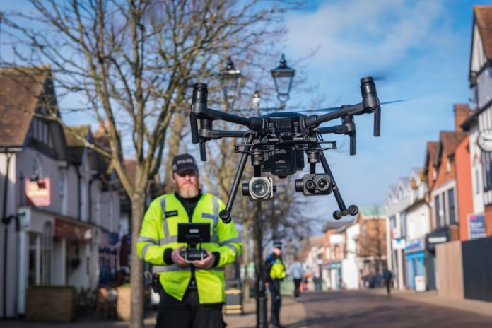
On their website the West Midlands Police in the UK discuss the way drones can be used to assist officers in scanning large areas in a short amount of time. These areas being: crime scenes, hard to reach areas, major incidents or looking for missing persons. The drones cost between 2.000 and 10.000 pounds (2.320-11.600 euros). The drones are operated by specially qualified officers that have trained under the Civil Aviation Authority (CAA) regulations. The drones are used for a short 15 minute period of time to minimize noise concerns. The drones are allowed to fly up to 120 meters high. The smallest drone has a top speed of 65 km/h. The drones can fly within 500 meters of the pilot. They make use of a lithium-polymer battery that can be charged either in buildings or on police vehicles.
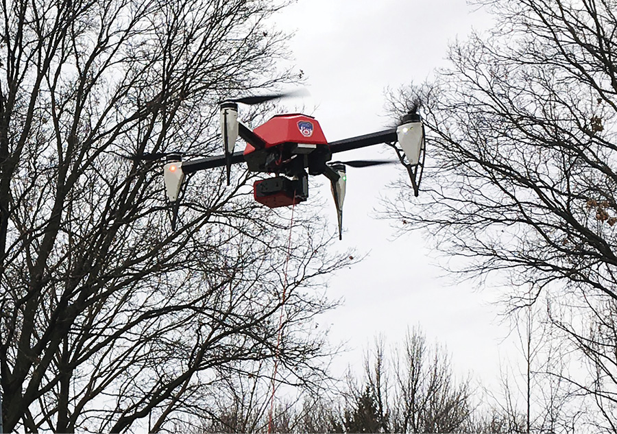
The Fire Department of New York (FDNY) has been using tethered drones at incident scenes since March 2017, The HoverFly drones are equipped with video and infrared cameras. They are able to evaluate fire travel, structural issues like cracks in a building or danger of collapse, and roof operations to determine if anything is unsafe and needs corrective action. HoverFly drones have a constant power source and are able to give very clear pictures. The drones are operated by pilots that are part of a command tactical unit that is dispatched from the FDNY command center.
Design research
Planning milestones
In the figure below a planning of the project can be seen.

Workload
Here an overview is given of what everyone has done per week.
Week 1
| Name | Student ID | Hours worked | Tasks done |
|---|---|---|---|
| Pepijn Hundepool | 1427520 | 9 | Intro videos + conference (1h), First meeting (1.5h), Meeting to choose subject's direction (1.5h), Studied and wrote summaries for papers (5h): [21], [22], [23], [24], [25] |
| Lucas Commissaris | 1451065 | 10 | Intro videos + conference (1h), First meeting (1.5h), Meeting to choose subject's direction (1.5h), Studied and wrote summaries for papers (6h): [6], [7], [8], [9], [10]. |
| Sven Passier | 1448781 | Intro videos + conference (1h), First meeting (1.5h), Meeting to choose subject's direction (1.5h), Studied and wrote summaries for papers: [1], [2], [3], [4], [5]. | |
| Bram van den Buijs | 1464647 | Intro videos + conference (1h), First meeting (1.5h), Meeting to choose subject's direction (1.5h), Studied and wrote summaries for papers: [11], [12], [13], [14], [15]. | |
| Stijn Borgers | 1495968 | 9 | Intro videos + conference (1h), First meeting (1.5h), Meeting to choose subject's direction (1.5h), Studied and wrote summaries for papers (5h): [16], [17], [18], [19], [20]. |
Week 2
| Name | Student ID | Hours worked | Tasks done |
|---|---|---|---|
| Pepijn Hundepool | 1427520 | 8,5 | Tutor feedback meeting (0,5h), Meeting with the group for setting up user needs (3h), Coming up with questions (2h), Another meeting with the group for setting up survey (3h) |
| Lucas Commissaris | 1451065 | 8,5 | Tutor feedback meeting (0,5h), Meeting with the group for setting up user needs (3h), Coming up with questions (2h), Another meeting with the group for setting up survey (3h) |
| Sven Passier | 1448781 | Tutor feedback meeting (0,5h), Meeting with the group for setting up user needs (3h), Another meeting with the group for setting up survey (3h) | |
| Bram van den Buijs | 1464647 | Tutor feedback meeting (0,5h), Meeting with the group for setting up user needs (3h), Another meeting with the group for setting up survey (3h) | |
| Stijn Borgers | 1495968 | Tutor feedback meeting (0,5h), Meeting with the group for setting up user needs (3h), Another meeting with the group for setting up survey (3h) |
Week 3
| Name | Student ID | Hours worked | Tasks done |
|---|---|---|---|
| Pepijn Hundepool | 1427520 | 7 | Tutor feedback meeting (0,5h), Setup technical specifications of a firefighting drone (1.5h), Group meetings (3h), Editing planning and wiki (2h) |
| Lucas Commissaris | 1451065 | 12,5 | Tutor feedback meeting (0,5h), Looking for contact information of the respective departments (2h), Finishing up survey and sending it (3,5h), Group meetings (3h), Problem statement and objectives (3,5h) |
| Sven Passier | 1448781 | Tutor feedback meeting (0,5h), Setup technical specifications of a police drone (...h), Group meetings (3h) | |
| Bram van den Buijs | 1464647 | Tutor feedback meeting (0,5h), Setup technical specifications of a medical drone (...h), Group meetings (3h) | |
| Stijn Borgers | 1495968 | Tutor feedback meeting (0,5h), Finishing up survey and sending it (...h), Group meetings (3h) |
Week 4
| Name | Student ID | Hours worked | Tasks done |
|---|---|---|---|
| Pepijn Hundepool | 1427520 | Tutor feedback meeting (0,5h) | |
| Lucas Commissaris | 1451065 | Tutor feedback meeting (0,5h), Research transport drones for State of the Art (3,5h), Create and edit wiki page State of the Art (1h) | |
| Sven Passier | 1448781 | Tutor feedback meeting (0,5h) | |
| Bram van den Buijs | 1464647 | Tutor feedback meeting (0,5h) | |
| Stijn Borgers | 1495968 | Tutor feedback meeting (0,5h) |
Week 5
| Name | Student ID | Hours worked | Tasks done |
|---|---|---|---|
| Pepijn Hundepool | 1427520 | ||
| Lucas Commissaris | 1451065 | ||
| Sven Passier | 1448781 | ||
| Bram van den Buijs | 1464647 | ||
| Stijn Borgers | 1495968 |
Week 6
| Name | Student ID | Hours worked | Tasks done |
|---|---|---|---|
| Pepijn Hundepool | 1427520 | ||
| Lucas Commissaris | 1451065 | ||
| Sven Passier | 1448781 | ||
| Bram van den Buijs | 1464647 | ||
| Stijn Borgers | 1495968 |
Week 7
| Name | Student ID | Hours worked | Tasks done |
|---|---|---|---|
| Pepijn Hundepool | 1427520 | ||
| Lucas Commissaris | 1451065 | ||
| Sven Passier | 1448781 | ||
| Bram van den Buijs | 1464647 | ||
| Stijn Borgers | 1495968 |
Week 8
| Name | Student ID | Hours worked | Tasks done |
|---|---|---|---|
| Pepijn Hundepool | 1427520 | ||
| Lucas Commissaris | 1451065 | ||
| Sven Passier | 1448781 | ||
| Bram van den Buijs | 1464647 | ||
| Stijn Borgers | 1495968 |
Appendix
This contains supplementary material for the text.
A. Consent Form
Information form for participants
This study is performed by Sven Passier, Pepijn Hundepool, Bram van den Buijs, Lucas Commissaris and Stijn Borgers students under the supervision of Elena Torta of the Control System Technology group at Eindhoven University of Technology.
Before participating, you should understand the procedure followed in this study, and give your informed consent for voluntary participation. Please read this page carefully.
About this study
The goal of this study is to examine what the requirements of (insert user) would be for a drone that could assist them in an emergency situation. You are asked to fill in the survey with questions about the functions of such a drone.
This study will take less than 5 minutes to complete and does not involve any risks.
Voluntary Participation
Your participation is completely voluntary. You can stop participation at any time. You can also withdraw your permission to use your data up to after completing this survey.
Confidentiality and use, storage, and sharing of data
This study has been approved by Elena Torta, teacher of the bachelor course Robots Everywhere of Eindhoven University of Technology. In this study experimental data will be stored. The anonymized dataset that, to the best of our knowledge and ability will not contain information that can identify you, will be used in this research and stored on a TU/e OneDrive account.
Further information
If you want more information about this study, the study design, or the results, you can contact Stijn Borgers (contact email: s.borgers@student.tue.nl). You can report irregularities related to scientific integrity to confidential advisors of the TU/e, whose contact information can be found on www.tue.nl.
Certificate of consent
By starting this study, I indicate that I have read and understood the study procedure, and I agree to voluntarily participate.
References
- ↑ 1.0 1.1 [1] Kardasz, P., & Doskocz, J. (2016). Drones and Possibilities of Their Using. Journal of Civil & Environmental Engineering, 6(3), 1–7.
- ↑ 2.0 2.1 [2] Hassanalian, M., & Abdelkefi, A. (2017). Classifications, applications, and design challenges of drones: A review. Progress in Aerospace Sciences, 91, 99–131.
- ↑ 3.0 3.1 [3] Rao, B., Gopi, A. G., & Maione, R. (2016). The societal impact of commercial drones. Technology in Society, 45, 83–90.
- ↑ 4.0 4.1 [4] Zhang, J., Hu, J., Lian, J., Fan, Z., Ouyang, X., & Ye, W. (2016). Seeing the forest from drones: Testing the potential of lightweight drones as a tool for long-term forest monitoring. Biological Conservation, 198, 60–69.
- ↑ 5.0 5.1 [5] Balasingam, M. (2017). Drones in medicine-The rise of the machines. International Journal of Clinical Practice, 71(9), e12989.
- ↑ 6.0 6.1 [6] Capucci, A., Aschieri, D., Piepoli, M. F., Bardy, G. H., Iconomu, E., & Arvedi, M. (2002). Tripling Survival From Sudden Cardiac Arrest Via Early Defibrillation Without Traditional Education in Cardiopulmonary Resuscitation. Circulation, 106(9), 1065–1070.
- ↑ 7.0 7.1 [7] Hoz, S. S., Aljuboori, Z. S., Dolachee, A. A., Al-Sharshahi, Z. F., Alrawi, M. A., & Al-Smaysim, A. M. (2020). Fatal Penetrating Head Injuries Caused by Projectile Tear Gas Canisters. World Neurosurgery, 138, e119–e123.
- ↑ 8.0 8.1 [8] Kuprin, D. S. (2017). Physical–chemical explanation of fire-fighting efficiency of FHF (fast-hardening foam) based on structured silica particles. Journal of Sol-Gel Science and Technology, 81(1), 36–41.
- ↑ 9.0 9.1 [9] Schlag, C. (2013). The New Privacy Battle: How the Expanding Use of Drones Continues to Erode Our Concept of Privacy and Privacy Rights. Pittsburgh Journal of Technology Law and Policy, 13(2), 1–23.
- ↑ 10.0 10.1 [10] Hashemi, S. R., Esmaeeli, R., Aliniagerdroudbari, H., Alhadri, M., Alshammari, H., Mahajan, A., & Farhad, S. (2019). New Intelligent Battery Management System for Drones. Volume 6: Energy, 1–7.
- ↑ 11.0 11.1 [11] Aydin, B. (2019). Public acceptance of drones: Knowledge, attitudes, and practice. Technology in Society, 59, 101180.
- ↑ 12.0 12.1 [12] Sherstjuk, V., Zharikova, M., & Sokol, I. (2018). Forest Fire-Fighting Monitoring System Based on UAV Team and Remote Sensing. 2018 IEEE 38th International Conference on Electronics and Nanotechnology (ELNANO), 663–668.
- ↑ 13.0 13.1 [13] Merkert, R., & Bushell, J. (2020). Managing the drone revolution: A systematic literature review into the current use of airborne drones and future strategic directions for their effective control. Journal of Air Transport Management, 89, 101929.
- ↑ 14.0 14.1 [14] Rosser, J. C., Vignesh, V., Terwilliger, B. A., & Parker, B. C. (2018). Surgical and Medical Applications of Drones: A Comprehensive Review. JSLS : Journal of the Society of Laparoendoscopic Surgeons, 22(3), e2018.00018.
- ↑ 15.0 15.1 [15] EUCHI, J. (2020). Do drones have a realistic place in a pandemic fight for delivering medical supplies in healthcare systems problems? Chinese Journal of Aeronautics, 1–9.
- ↑ 16.0 16.1 [16] Floreano, D., & Wood, R. J. (2015). Science, technology and the future of small autonomous drones. Nature, 521(7553), 460–466.
- ↑ 17.0 17.1 [17] Khan, M. N. H., & Neustaedter, C. (2019). An Exploratory Study of the Use of Drones for Assisting Firefighters During Emergency Situations. Proceedings of the 2019 CHI Conference on Human Factors in Computing Systems, 1–14.
- ↑ 18.0 18.1 [18] Restas, A. (2015). Drone Applications for Supporting Disaster Management. World Journal of Engineering and Technology, 03(03), 316–321.
- ↑ 19.0 19.1 [19] Liu, Z., Kim, A. K., & Carpenter, D. (2007). A study of portable water mist fire extinguishers used for extinguishment of multiple fire types. Fire Safety Journal, 42(1), 25–42.
- ↑ 20.0 20.1 [20] Aydin, B., Selvi, E., Tao, J., & Starek, M. J. (2019). Use of Fire-Extinguishing Balls for a Conceptual System of Drone-Assisted Wildfire Fighting. Drones, 3(1), 17–32.
- ↑ 21.0 21.1 [21] Moore, J. (2013). U.S. Patent No. 2013/0134254. Maryland
- ↑ 22.0 22.1 [22] W, G.Y. & K, K.W. (2019). U.S. Patent No. 10,413,763. Korea
- ↑ 23.0 23.1 [23] Anania, E. C., Rice, S., Pierce, M., Winter, S. R., Capps, J., Walters, N. W., & Milner, M. N. (2019). Public support for police drone missions depends on political affiliation and neighborhood demographics. Technology in Society, 57, 95–103.
- ↑ 24.0 24.1 [24] Feeney, Matthew, Surveillance Takes Wing: Privacy in the Age of Police Drones (December 13, 2016). Cato Institute Policy Analysis No. 807, Available at SSRN: https://ssrn.com/abstract=2919439
- ↑ 25.0 25.1 [25] Manjikian, M. & Army War College (U.S.). (2017). A Typology of Arguments about Drone Ethics. Amsterdam, Netherlands: Amsterdam University Press.