PRE2019 3 Group3: Difference between revisions
TUe\20181902 (talk | contribs) |
TUe\20181902 (talk | contribs) |
||
| Line 206: | Line 206: | ||
==== Steep Slopes ==== | ==== Steep Slopes ==== | ||
For kilometer-scale baselines, slopes steeper than the angle of repose, the steepest angle of descent relative to the horizontal plane to which a material can be piled without slumping, are scarce. In the complete MOLA (Mars Orbiter Laser Altimeter) data set there are a total of 105 point-to-point segments have slopes steeper than 35 degrees [https://agupubs.onlinelibrary.wiley.com/doi/pdf/10.1029/1999JE001051] | For kilometer-scale baselines, slopes steeper than the angle of repose, the steepest angle of descent relative to the horizontal plane to which a material can be piled without slumping, are scarce. In the complete MOLA (Mars Orbiter Laser Altimeter) data set there are a total of 105 point-to-point segments have slopes steeper than 35 degrees. 9 of these are probably data errors. The slopes of steep segments are sorted according to some feature classes in the table shown below [https://agupubs.onlinelibrary.wiley.com/doi/pdf/10.1029/1999JE001051]. | ||
[[File:steepslopes.PNG]] | [[File:steepslopes.PNG]] | ||
Revision as of 14:52, 16 February 2020
Introduction
General information
Information about the groupmembers and the logbooks each week can be found here.
A full list of all the references used can be found here.
Problem statement
Interplanetary exploration will get more and more important in the future as the idea of a space colony gets closer and closer to reality. One of the ways to explore another planet without risking human lives is to send a robot there. Think about robots like the Opportunity and Curiosity rovers that were send to Mars for investigation. These robots, for the most part, need to act on their own and should, ultimately, be able to explore the surface of the planet completely autonomous. One of the things that one of these robots should be able to do is navigate from point to point by themselves, overcoming the obstacles it might encounter on its path. The Curiosity rover was the first to be equipt with autonomous navigation [1]. For this project, our group would like to investigate the possibilities for autonomous navigation for a robot on such a planet, including the best way to specify its location, sense its surroundings and path-finding, and ultimately simulate our solution in a virtual environment.
Setting
In order to set a goal for ourselves it is important to set some boundaries on the situation we would like to study. For this project we will focus on the planet Mars. It is assumed that the robot already knows the initial position and goal position. It does not know what the surface of the planet in between looks like.
Users
The users of these autonomous mining robots will be the space colony. This colony will entrust these robots with gathering materials for their building and renovation needs.
The secondary users are the engineers that may have to repair mining robots.
Tutor meeting notes:
- Colony
- Engineers
- Manufacturers (NASA/ESA)
STILL HAS TO BE CHANGED
space agencies are probably the biggest users, they need the technology for their robots
Objectives
The main goal is to give a proposal for a robot that can navigate and move on Mars from point A to B through unknown land autonomously. In order to let the robot navigate autonomously, it needs to be able to do a couple of things.
- Coördinate system: Firstly, the robot needs to have a proper coördinate system to use on Mars for specifying its initial position, its goal position and possibly map obstacles on the way.
- Sense its environment and gather information: Secondly, the robot needs to be able to gather data about its surroundings to determine its world view and come up with a path. It also needs to be able to determine its location in the chosen coördinate system.
- Determine a path: When the robot has gathered its data from its surroundings it needs to be able to calculate the best path to take in order to reach its goal.
- Move from point to point: When the robot has calculated its path it needs a way of actually moving to the goal point. For this we need to research the best way to move forward on Mars. In other words, what are the best kind of tires to use for the environment or should it use tires at all?
Another objective is to create a virtual simulation demonstrating mostly the path-finding capability of the found solution. This simulation should feature a random generated terrain that is similar to that of Mars, the robot being able to sense what it would be able to in the real world, the same driving capabilities as in the real world (things like how steep of a slope the robot can overcome) and simulate the path-finding capabilities of the robot in this situation.
Approach
Milestones
- Create a coordinate system for Mars that can be used by the robot.
- Relevant specifics of Mars environment that influences the navigation are known.
- Being able to create a virtual ground environment in a simulation that is similar to Mars.
- Determining the optimal specifics of the robot and it's sensors.
Deliverables
- Research on all relevant topics/objectives.
- Suggestions for a (best) solution for each objective.
- Virtual simulation
- Presentation
Who will do what?
For the beginning of the project each groupmember will focus his studies on a certain area. The work division is as follows:
- Finn will focus on determining how the environment of Mars looks like and how this can be recreated in the virtual simulation.
- Nick will focus in getting a coördinate system usable for location on Mars & look at its planetary properties.
- Rik will focus on the (potential) user studies of this topic.
- Stefan will focus on how the robot will travel on Mars and determining how the robot will see its environment, in other words, which sensors does it needs and how does it create an image of its surroundings.
- Zeph will focus on the virtual simulation and thinking about how the robot will determine its path.
Planning
Week 1: Decided on a subject for the project.
Week 2: Work on plan and finish research.
Week 3: Implement findings of research into wiki.
Carnaval
Week 4: Potentially Choose experiment and execute experiment.
Week 5: Potentially Implement findings of experiment.
Week 6: Work on wiki.
Week 7: Work on wiki.
Week 8: Finish presentation. STILL HAS TO BE CHANGED
State of the art
[2] This paper describes multi createria dicision making methods for autonomous navigation for ground robots. According to the paper, this method should be able to let the robot make more precise alternative evaluations and minimize the probability the robot will be stuck or collide with objects.
[3] This paper is focused on underground mining. Uses four-wheel vehicles that minimizes curvature variation in the path it takes and stays in a certain safety margin from the mine walls. It presents a study that uses a B-spline for path determination. A B-spline (or basis spline) is a spline function. This means that the function can be reconstructed by connecting different polynomials. All possible spline functions can be reconstructed by connecting different B-spline functions.
[4] The focus of this paper lies on aerial robots in an underground mine. These aerial drones use both visual and thermal cameras to ensure a good understanding of the surroundings in order to map in these dark, dust-filled areas.
[5] This paper describes a framework for terrain characterization and indentification. This framework is composed of vision-based classification of upcoming terrain, terrain parameter identification via wheel-terrain interaction analysis and acoustic wheel-terrain contact signatures based terrain classification.
[6] This paper provides a new solution to the simultaneous localization and mapping problem with six degrees of freedom. he additional three degrees of freedom are yaw, pitch and roll angles. A robot on a natural surface has to cope with all of these degrees of freedom. With this solution an autonomous mobile robot can create a 3D map of a scene such as a mine or a cave.
[7] This article shows the parts of planet Mars that the robot is most likely to be on in case of harvesting missions.
[8] Mars orbital data explorer
Mars Terrain
[9] This paper investigates the slope distribution in the northern hemisphere of Mars from topographic profiles collected by the Mars Orbiter Laser Altimeter.
[10] This paper describes the calculation of slopes and the characterization of surface roughness using profiles obtained by the Mars Orbiter Laser Altimete.
OLD STATE OF THE ART:
General
[11] NASA plans to use multiple mining robots together in order to supply a colony with materials. These robots should work together in a "swarm". They will work individual first, but when one robot finds something interesting it will call the other robots in order to help it with extraction.
[12] Competition for students to build mining robots. Maybe a good place for inspiration.
[13] Maybe interesting. Not looked at yet.
[14] NASA page including all kinds of information sources about space colonies.
[15] Space Settlements: A Design Study. Includes information about all aspects of a space settlement including resources needed to maintain and expand.
[16] What do we need to know to mine an asteroid? States that science is nearly able to develop a space mining technology, only further knowledge of asteroid contents is needed.
Locating and mining materials
[17] While not about robots, this paper presents the method of using a detailed world model of the geological structure of the ground in order to locate different ores in the ground. It uses different sensors across the mining area, which could be placed on a robot which moves around, in combination with a supervised learning algorithm to build this world model. ~Might be interesting. No access to full paper yet however.
[18] This paper describes methods to build the spectral library to map geology on minefaces. The library includes multiple environmental conditions such as the inclusion of shade and moisture. Such a spectral library can be used by autonomous mining robots to identify different materials.
[19] In this paper an automated technique that allows a robot to classify the shape and other geological characterics of material from a 2D photographic images and stereographic data. This technique first seperates the material from the background after which various metrics are used to classify the materials sphericity, roundness, and other geometric properties.
[20] In this paper a new automated geological perception system is presented. It detects and classifies geological structures by using hyperspectral imaging sensors and a learning algorithm. Ultimately the system builds a rich model of the operating environment which can be used in autonomous mining.
[21] This paper gives information about an economically favourable mining technique called Optical mining. This method of mining will provide affordable mission consumables and radiation shielding.
[22] Asteroid Mining. Explores possibilities for space mining on asteroids. This paper comes to the conclusion that a solar powered mining vehicle, that runs on water and that mines water and platinum group metals, would be potentially feasible in the near future.
[23] Asteroid Mining. States how far we are on developing space mining technology. This might happen within a decade, once a cost-effective method is found. Also addresses financial, environmental and legal issues.
Transporting materials
[24] June 26, 1951 R. w. GAUSMANN APPARATUS FOR TRANSPORTING MATERIALS 5 Sheets-Sheet 1. Is about a technique for for transporting materials without changing the compounds temperature which may be necessary to prevent chemical changes in the material being transported, or to prevent it from solidifying within the car whereupon it would have to be heated to be removed therefrom.
[25] Describes a bag with means for vacuuming an internal space of the bag. This can extend the lifetime of organic matter.
[26] Extraterrestrial construction materials by M.Z.Naser. This review explores the suitability of construction materials derived from lunar and Martian regolith along with concrete derivatives, space-native metals and composites, as well as advanced and non-traditional materials for interplanetary construction.
[27] Space-native construction materials for earth-independent and sustainable infrastructure. This review covers feasibility of exploiting in-situ lunar and Martian resources as well as harvesting of elements and compounds, from near Earth objects (NEOs), to produce extraterrestrial materials suitable for construction of space-based infrastructure.
[28] Materials and design concepts for space-resilient structures. This paper presents a state-of-the-art literature review on recent developments of “space-native” construction materials, and highlights evolutionary design concepts for “space-resilient” structures.
Society
[29] Societal challenges in sustainable space mining. This article focuses on sustainable space mining and the issues it brings up. Potential issues are: 1) Legal issues 2) Issues in investment 3) International disputes 4) Environmental protection.
[30] Space Law in Asteroid Mining. In order to ensure legitimate space mining, countries need to update their own legislation and cooperate internationally in this area.
Research
Path Finding
Virtual Simulation
The goal of the simulation is to simulate the path-finding behaviour of a robot in a three dimensional environment. As seen in the objectives, this simulation should feature a random generated terrain that is similar to that of Mars, the robot being able to sense what it would be able to in the real world, the same driving capabilities as in the real world and simulate the path-finding capabilities of the robot in this situation. The first thing that should be established is the software that will be used for the simulation. While there are many programs for simulation the two main options that jumped out were NetLogo and Unity. Both these programs are easy to use and can be used for three dimensional simulation. First lets look at NetLogo. NetLogo offers the basic tools to build a single- or multi-agent simulation. While mainly made for two dimensional simulations it has a three dimensional option that allows for simulation in a three dimensional environment. However, according to the developers themselves, this three dimensional version is not up to the standards of the main two dimensional software [31]. Even though NetLogo allows for quick setup of a simple simulation of agents, it seems very limited in building environments for the agents to exist in. For this reason, its simplicity is both its strong point and its weakness. The other option is Unity. While Unity is made for game development it could also serve as a great platform to build a simulation. It offers great tools to generate a three dimensional environment and has very little limits in what can achieved. While it is more work to have a simulation up and running in Unity as compared to NetLogo, Unity seems like the better option. There will be almost no constraints while making the simulation.
Relevant information about Mars
General
Mars is a relatively small planet in the Solar system with a surface area of 144.798.500 squared kilometres. The highest point on Mars, the summit of Olympus Mons, is at 21.229 meters above the Mars areoid, and the lowest point on Mars, the bottom of the Hellas impact basin, is at 8,200 meters below the Mars areoid. This makes the topographic range of Mars 29.43 km while Earth has a topographic range of 19.7 km, meaning Mars is much 'rougher' in comparison with Earth. The Mars areoid is defined at a radius of 3.396.000 metres from the centre of mass. It is an useful measurement to define elevation. Mars has a equatorial radius of 3.396km and a polar radius of 3.376km.
Coordinates
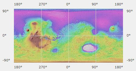
An easy way to map coordinates is by using longitude and latitude coordinates.
On this map you see we can divide positions in x & y coordinates using a Cartesian coordinate system. 1 degree longitude = 59.27 km (x-axis), 1 degree latitude = 58.923 km (y-axis) The difference between the two numbers is caused between the difference in polar radius and equatorial radius.
Slope distribution
Median Slope
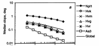
The median slope differs based on the based on the baseline length, the length over which the height difference is measured, which is used while calculating the median slope. The graph shown below shows the median slope of different geological formations based on the baseline length which ranges from 0.1 to 100 km [32]. The graph shows that the median slope decreases the higher the baseline length.
Steep Slopes
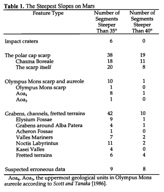
For kilometer-scale baselines, slopes steeper than the angle of repose, the steepest angle of descent relative to the horizontal plane to which a material can be piled without slumping, are scarce. In the complete MOLA (Mars Orbiter Laser Altimeter) data set there are a total of 105 point-to-point segments have slopes steeper than 35 degrees. 9 of these are probably data errors. The slopes of steep segments are sorted according to some feature classes in the table shown below [33].


