PRE2016 3 Groep12: Difference between revisions
| Line 50: | Line 50: | ||
Campus citizens and visitors | Campus citizens and visitors | ||
==Scenario== | |||
==Financial Model== | ==Financial Model== | ||
Revision as of 08:37, 23 March 2017
Group members
- Bibi Huijgen - 0906203
- Jamiro Leander 0890417
- Jari de Kroon - 0888168
- Juan van der Heijden - 0898805
- Plamen Pasliev - 0890518
- Stan Roelofs - 0892914
Introduction
In the year 2015 over 500000 cases of burglary and theft were recorded in the Netherlands [1]. It is by far the most common type of crime, around 57% of all crimes recorded in 2015 were related to burglaries. A recent trend is to setup neighbourhood prevention systems through mobile applications, however the effectiveness of this is limited due to the fact that most people will sleep at night when most burglary cases occur. Our aim is to reduce the big number of burglaries through the application of surveillance / security drones in areas where criminal rates are high. The drones should detect inappropriate behavior using an anomaly detection system.
Several issues arise in the application of drones:
- Legal issues regarding no fly zones and privacy.
- Technical issues related to the safety of the drone, since it will be flying near people.
- Using drones might be costly.
Besides the decreased rate of crimes, the introduction of this technology will allow for faster response times to other related crimes and hazards. The goal is to give the citizens an increased sense of security and safety.
Objectives
- Research what the effects on society will be when security drones are deployed.
- Research what the financial benefit would be to deploy surveillance drones.
- Research the legal issues regarding surveillance drones.
- Find out what the police thinks about surveillance drones.
- Find out what people think about surveillance drones.
Approach
- Research state of the art technologies using books and articles.
- Make an analysis of the current legislation regarding relevant topics such as filming humans and flying drones. Find out how privacy can be preserved and finally investigate if the current laws can be changed and how.
- Find out what people think of drones surveilling their neighbourhoods by making a survey and interviewing people.
- Make a financial model in Java where the input is an area and level of security and the output is the number of drones, cameras, or people that are needed to watch the area. To make the model we first have to use a drone to find out how high a drone can fly while still detecting humans without issues. We also need to know the costs of drones, security cameras, and people, and how long drones can fly before they have to be charged.
Product idea
We plan to use state-of-the art drones which are already equipped with cameras able to film in high resolution and framerate. We drafted a list of requirements for the product which you can find here. Afterwards we found a suitable drone candidate: DJI Phantom Pro 4. The drone is already programmable and supports autonomous flying, which means that they will follow a certain preprogramed map, and will deliver the footage to a human operator who will be responsible for detecting criminal activity and can take control of the device at any time. We also think to implement state-of-the art human detection software which will highlight humans filmed by a surveillance drone. We learnt that currently TU/e cameras do not have such software implemented so it would be a good addition to our system.
Security issues
In order to make the process secure enough we have to add some sort of encryption on multiple levels of the communication. We asked Tanja Lange, who is a cryptology proffessor in TU/e, to share some of her insight about this issue.
Stakeholders
There are several parties involved and every party has its own particular position. We will define how all are involved:
Government
Eindhoven municipality
TU/e security
Campus citizens and visitors
Scenario
Financial Model
The financial model will be a tool that can be used in order to derive conclusions on the cost effectiveness of applying drones. It will take into account many variables such as wheather, hardware costs of the drones as well as the cost of cameras that are currently used. All of this will be combined into one graphical user interface (GUI) where variables can be assigned values and results can be interpreted. There will be options for manual calculations, as well as options where the tool will optimize certain values, for example the number of drones to be used. For this project we will take the TU/e campus as an example where drones will be applied, however the tool will be developed in such a way that it can be applied to different areas as well.
Human detection software
For the Human detectin software we found a framework called openCV: http://opencv.org/
We are going to try and implement this framework so that we can see from how far the drone's camera can still recognize a human.
Drone charging
Costs
Listed below are the factors we think will play a role in the costs of implementing this system in society:
Drones
One time costs
- Cost of a drone
- Cost of camera
- Cost of charging stations
- Amount of drones needed
- Amount of charging stations needed
Continues costs
- Range drone can search (height detection, speed)
- Battery life
- Cost of electricity
- Lifetime of a drone
- Detection efficiency
Cameras
- Cost of cameras
- Lifetime of a camera
- Amount of cameras needed
- Percentage of ground covered
- Detection efficiency
Police
- Police salary
- Cost of police car
- Amount of police needed
- Amount of police cars needed
- Covered ground
- Detection efficiency
Model
Area
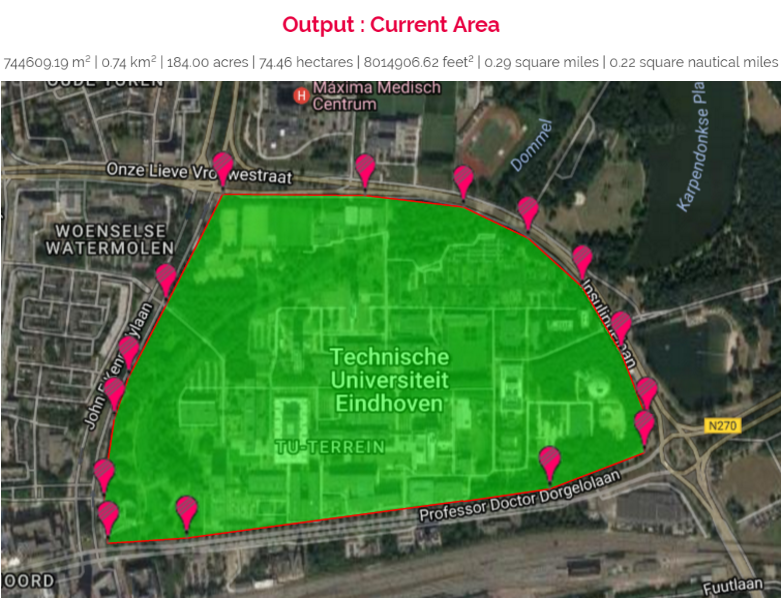
First of all the area where the drones will fly should be defined. In our case this will be the area of the TU/e campus. An external tool [2] was used to find this area which is equal to 0.74 km^2, this is shown in the image below.
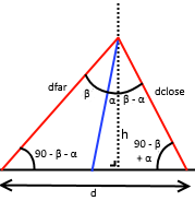
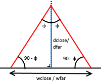
Besides the size of the area to be scanned, the size a drone can see at once is also of importance. Because of the way how cameras work, this area is a trapezoid. In order to calculate this area, we define the front view of the drone to be the side where the camera is located and we define the side view of the drone to be on either side of this front view. Furthermore we define the following variables:
- h = the height the drone is flying
- alpha = the tilt angle of the camera of the drone
- 2*beta = the vertical field of view of the camera in degrees
- 2*phi = the horizontal field of view of the camera in degrees
2*phi depends on the camera that is used for the drone. For the DJI pahtom 4 pro for example this angle is 94 degrees. However since we want to use this financial model with different types of drones we decided to keep this as a variable. The images below describe the area which the drone can see. The image on the left describes the situation from the side view, the other image descirbes the situation from the front/back view.
Then, assuming we never look past the horizon, the area A the drone can see is:
- A = .5*(wclose+wfar)*d[3], where:
- wfar = 2*dfar*tan(phi)
- wclose = 2*dclose*tan(phi)
- dfar = h/cos(beta+alpha)
- dclose = h/cos(beta-alpha)
- d = h*tan(beta+alpha) + h*tan(beta-alpha)
We can now already calculate some simplified statistics. If we would ignore all other factors, we can calculate how much of the area of the TU/e campus can be covered by the drone given its speed, height, tilt angle of the camera and the time frame t. One last thing that we took into consideration is that you can't see as good at a distance as you can up close, so if dfar is longer than a 150 meters, we cut it off at 150 meters and recalculate beta for all 'far' variables.
For example for a speed of 10 km/h, a height of 25 meters, a camera tilt of 25 degrees and a time frame of 15 minutes we get the following result:
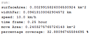
Here surfaceArea corresponds to the area A that the drone covers at any point, widthFar corresponds to wFar, move Area corresponds to the total area that the drone has seen. Finally the percentage of the TU/e campus that is covered is shown. In this case 32.88 percent of the campus was covered in 15 minutes. If we were to use three drones then the entire campus would be covered in 15 minutes.
This calculation however is missing some important things still. First of all drones cannot fly all the time due to battery life and the wheather effects to some extend. In the following sections we will discuss how we will deal with these aspects in our model.
Battery Life
Wheather
The next variable we take into account is the wheather. Depending on which drone we use, the drone will not always be able to fly due to wheather conditions.
Drones have a certain resistance to wind speed. In the case of the DJI phantom 4 this is 10 m/s wind[4]. When looking at wind data gathered over a time period of about 30 years, we can conclude that this drone can fly in 98.12% of all time because of the wind[5]. Our tool will take into account wind resistance depending on which drone will be used.
Besides wind there is also a lot of rain in the Netherlands. Most drones cannot fly in the rain since they are not waterproof.
Conclusion
Law analysis
Current legislation
Filming humans
Currently, cameras film the campus almost everywhere. The footage is watched by security people in the control room and they decide whether action has to be taken. Footage is preserved for 7 days and then automatically deleted. In case there has been reported a crime, the relevant footage is filtered and used for security objectives. This footage is locked and only shared with responsible and legal authorities.
In case of drones instead of standing cameras, the footage will be treated equally. It will remain available for 7 days and after that all is deleted. Without detected anomalies, nobody sees the footage anymore.
Thus, the subject of privacy is comparable to current standards. Nowadays, all footage is filmed and analyzed and this will be the same situation using drones.
Flying drones
Legislation about flying drones can be found in "Regeling modelvliegen", which is about aircraft that are not able to carry a human, and are strictly used for demonstration, recreation, or sport.
Where can you fly drones ?
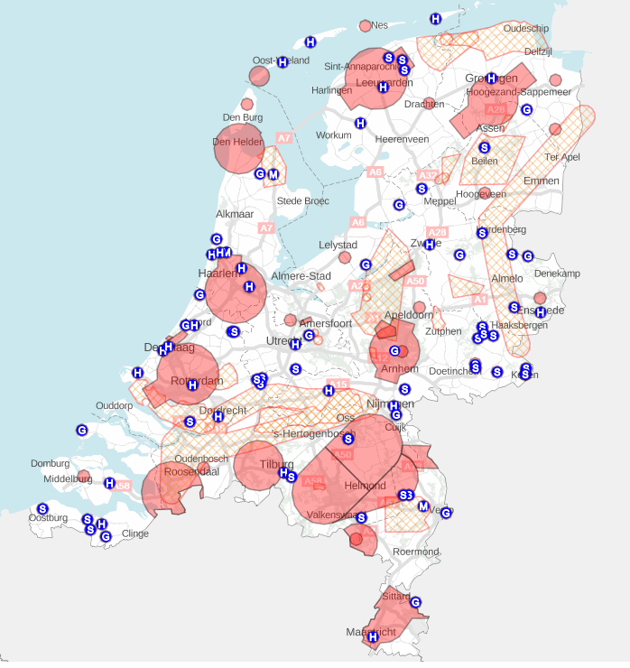
Certain areas are restricted for drones for example near airports. You are only allowed to fly drones in airspace category G, which is the free airspace. Sometimes there is a temporary restriction for example at big events. The red areas in the following image are restricted zones.
Apart from flying in airspace category G, there are some more general rules about flying drones:
- You are not allowed to fly higher than 120 meters above the ground or water.
- You have to give way to all other aircraft.
- You have to fly at a safe distance from people and buildings.
- You always have to be able to see the drone.
- You cannot fly in the dark.
Rules about drone specifications:
- Weight of the drone must not exceed 25 kilograms. (Will be changed to 4 kilograms)
Rules for business use of drones
The following rules hold if you want to use a drone to generate income. For example video production companies filming using a drone equipped with a camera, or inspection companies that want to inspect places that are difficult to reach.
If you want to use drones for business, you need a permit. There are different kinds of permits, it depends on the situation which one you need. If you are the pilot, you need a pilot license. The company that wants to use the drone needs a RPAS Operator Certificate (ROC). There are two kinds of ROC’s, ROC and ROC-light, which one you need depends on the weight of the drone and the height or distance you want to fly the drone at. The owner of the drone needs a proof of airworthiness and a proof of registration to the aviation register.
Penalties:
- Fines
- Confiscation
- Jail
How can privacy be preserved
Footage is stored only 7 days. Without any report of anomalies, the footage is deleted forever. In case people detect crimes or theft etc, the relevant footage is securily distributed to the parties involved (government security, police). Nobody has access to these images but the head of security, all footage is locked safely.
Obviously, safety is considered more important than privacy in case of an offense.
Can the law be changed, if so, how?
Plans of European Commission
The European Commission believes unmanned aircraft is a sector that is developing fast, and has a lot of potential for growth and to create jobs. In the next 20 years the drone sector in Europe is expected to employ more than 100,000 people, and have an economic impact of more than 10 billion euros per year. [8] "Unmanned aircraft" includes large aircraft, which resemble in terms of size and complexity manned aircraft, but also small consumer aircraft. Especially those smaller consumer aircraft are being used more frequently in the European Union. However, the rules are different for each country and often not everything is addressed.
Therefore the European Commission is working on new rules regarding drones. They define three categories of unmanned aircraft, each of these categories has different safety requirements which are proportional to the risk of the drones in that category. The categories are:
- “Open” (low risk): no authorization required to operate the aircraft, as long as forbidden or restricted areas, defined by the national aviation authority (NAA) are respected. Safety is ensured by operational limitations, mass limitations, product safety requirements, and a set of operational rules.
- “Specific” (medium risk): authorization required by a NAA, a risk assessment has to be performed by the operator. For certain lower risk scenarios, a simple declaration sent by the operator to the NAA will be sufficient.
- “Certified” (higher risk): requirements are similar to those for manned aviation. The process is comparable the process for manned aviation, oversight by NAA and European Aviation Safety Agency (EASA) will be required.
A prototype regulation[9] was presented in the summer of 2016. The document is a prototype regulation for the operation of drones in the open and specific categories. It does not constitute any formal commitment, its purpose is to inform and consult stakeholders. Feedback will be gathered which will be used to develop the actual regulation. It represents the current views of EASA. There is also an explanatory note[10] which provides the rationale and background for the prototype regulation. This regulation is supposed to enter into force in 2019.
Summary of Prototype Regulation
The prototype regulation addresses the “open” and “specific” categories.
Regulation should be proportionate to the nature and risk of the type of drone operation. It should take into account: the type of operation and whether the operation is open to the public; how dangerous the operation is to other air traffic, or persons and property on the ground; the type of airspace used; the complexity and performance of the aircraft; the type, scale, and complexity of the operation that is performed.
The risk of operating a drone varies depending on the characteristics of the drone and the type of operation. Therefore there should be different rules for different categories, based on risk assessment and performance.
The higher risk operations of unmanned aircraft should regulated similarly to manned aircraft, which includes the certification of the aircraft.
The lower risk operations should be regulated by less strict requirements. These operations will be subdivided into the “open” and “specific category”. Risk assessments should be conducted, in order to reduce the administrative burden for operators and authorities. Standard scenarios should be identified.
Open Category
Operation of unmanned aircraft in this category will fall into one of the following subcategories:
- A0: Operation that poses a negligible risk of severe injury to people on the ground or damage to manned aircraft. Requires neither specific pilot competence nor age limitations. Operations in this category should be conducted up to a height of 50 meters above ground level. Operators should maintain visual line of sight and the drone should not exceed a horizontal distance of 100 meters from the operator. The drone itself should have a weight of at most 250 grams, and a maximum speed of less than 15 meters per second.
- A1: Operation complying with requirements ensuring that they pose a negligible risk of severe injury to people on the ground or damage to manned aircraft. Requires neither specific pilot competence nor age limitations. Operations in this category should be conducted up to a height of 50 meters above ground level. Operators should maintain visual line of sight, and be at least 14 years old. The drone should have a weight of at most 25 kilograms.
- A2: Operation complying with requirements ensuring that they pose a limited risk of severe injury to people on the ground or damage to manned aircraft. Operators should be registered, and equipped with geofencing (virtually defined geographic boundaries) and electronic identification. Operations in this category should be conducted up to a height of 50 meters above ground level. The operator should maintain a minimum horizontal distance of 50 meters from uninvolved persons. Operators should maintain visual line of sight, be at least 14 years old, and have appropriate familiarisation according to the user manual of the drone. The drone must be equipped with geofencing and electronic identification systems. The drone should have a weight of at most 25 kilograms.
- A3: Operation complying with requirements imposing technical mitigations, like geofencing and electronic identification. These operations pose a higher risk of severe injury to people on the ground or damage to manned aircraft, and are operated by registered operators with higher competence. Operations in this category should be conducted up to a height of 150 meters above ground level. The operator should maintain a minimum horizontal distance of 20 meters from uninvolved persons. Operators should either maintain visual line of sight, or have an observer in visual line of sight. Operators should also be at least 14 years old, carry evidence of their competence of flying unmanned aircraft, and have the appropriate familiarisation to minimise the risk to third parties.. The drone must be equipped with geofencing and electronic identification systems. The drone should have a weight of at most 25 kilograms.
Specific Category
Operators should submit an operational declaration to the competent authority.
The EASA shall provide standard scenarios, for which a risk assessment has been conducted, and mitigating measures have been identified.
If the operation does not correspond to any of the standard scenarios, the operator shall conduct a risk assessment and identify mitigation measures in order to limit the risk to an acceptable level. The operator should consider key factors such as operational area and conditions, and the category of airspace. The operator should also provide an operations manual adapted to the type of operation.
After receiving an application for operational authorisation, the competent authority verifies that the application contains all the required information and documentation. The authority then decides whether or not they give an authorisation. The authorisation can be for limited or unlimited duration. This authorisation can later be suspended, revoked or amended if the operational conditions change.
Survey analysis
The implementation of drones in daily, security TU/e campus life will be a social matter as well as a technological one, too. We decided to analyse three visions on safety guarantee by drone implementation, namely the perspective of:
- TU/e Security
- Police Office, Community of Eindhoven
- Students living on the TU/e campus
We chose to interview the Head of Security TU/e and a police officer specialized in drone authorization, community of Eindhoven Noord-Brabant. The students had to fill in a survey as this would allow us to reach a broad group of people.
Interview
TU/e security
Police Office, Community of Eindhoven
On Monday the 20th of March, we spoke to an officer of police faculty Eindhoven-Noord. He gave the general view of the police in Eindhoven considering the use of drones and the possibilities. It was rather difficult to get in contact with the right people and nobody actually took responsibility. This can be explained by the fact that the police is not that used to innovative technology: drones are no focus point in general. Below, we provide a summary of the relevant details of the conversation.
The use of drones of TU/e campus is currently not possible. Eindhoven is a ‘no-flyzone’, which means that it is forbidden to use drones here. The use of drones in private cases is possible and this could be of use considering TU/e. When you want to use a drone as a company, you need official authorization of the government, city of Eindhoven. The certificate that is needed to get authorization follows a training. This training learns people how to fly drones and assures that the people who will use the drones, are qualified. Nevertheless, this training costs 1500 euros and the use of the drone will still be restricted to a specific location and timespan.
The no-flyzone of Eindhoven is caused by the stationing of a military base nearby. Besides, drones in the air can distract pilots by influencing their radar signal. However, the police are experimenting with the use of drones for surveillance irrespectively of the restricting laws that prevent them from practical use. It is important to be prepared when legislation changes and government will allow use of drones. Situations where drones could come in handy, are cases where large groups of people gather. At the same time, these moments increase danger as failure of the drone will harm a lot of people at the same time.
In conclusion, police is testing the possibilities of drones. Currently, Eindhoven city is restricting the use of drones for surveillance due to risk of technical errors and the negative influence on radar. To use drones for security on the TU/e campus, legislation has to be changed and the drones that are used must be of high quality to limit damage risk. In the future, drones can be implemented but for now their use is restricted as the technology is not yet dependable enough.
Survey
Students living on the TU/e campus
Analysis of results
Conclusion
Planning
Gantt chart: https://drive.google.com/open?id=1bb1QMkg4TYDTVDhT7nHERBCg_1VZtb98BMwWiS9wT6I
Conclusion
Discussion
Weekly logbook
Week 1 Starting here, the project was introduced and we formed groups. To generate an innovative and feasible idea, we held several brainstorm sessions. Coming up with a realistic approach to cure a relevant problem using technology, we shifted from several perspectives. In the end, we formulated a topic of research that entailed both security issues and privacy legislation. The basic ideas were covered in a presentation, to be given in week 2. We tried to create slides that were concise and complete, without too much text and with use of visuals.
Week 2 The presentation was completed and we started on the Wiki page. We figured that the regular update of the Wiki will contribute strongly to our progress. Besides, this logbook gives a good overview of our objectives and the aspects of the project that were already covered.
On Thursday, the presentation of the chosen project challenge will be given. Feedback from the other students and the expert panel can be implemented.
Week 3 After getting feedback on our first presentation, we had to change important aspects of our research plan. The most important parts that needed attention were stakeholders, privacy and benefit. We devided tasks, related to personal skill. You either work on programming or on the social/public part that considers law. In the future, it will be important to keep close communication between group members to ensure that everybody understands the progress in the two directions. It is obvious that the technology and society must work together to realize success.
Besides deviding tasks and narrowing down the procedure, time management was a very important part of this second week. The planning of the project needed a lot of time but it is a precondition for success. Now we know what, when and how to deliver parts and when we stick to the Gantt chart, we will realize an optimal research project.
We presented our time planning including the deadlines and tasks we defined. This is an important moment for feedback, as this is the last moment to check your project planning and idea in public. Something else that needed attention, was our resource allocation. It was important to check whether our ideas were feasible. After all, we planned out a detailed project and included our feedback.
Week 4 The division of tasks, created together with the Gantt chart, was executed this week for the first time. On Monday, the group was split in two, where three of us started to create the financial model and try the drone while the others focused on law and legislation. This second group also tried to contact the police office. We suspected that officers would have a very realistic view on our project and their opinion should be taken seriously. Unfortunately, one of our group members had an accident so we were working with five for the majority of this week.
On Thursday, we planned a feedback session with our expert panel. Learning goals will be discussed and evaluated.
Feedback on Thursday was mainly focused on following parts: - The target groups for our surveys; - Creating the boundaries for our research, mostly defining an area (e.g. the TU/e campus); - Formulating scenarios to present to the participants in questionnaires; - Find out what the security legislation is with regard to the chosen area; - Check European Commission legislation
Based on these instructions, we chose TU/e campus as target area and we divided tasks again. Two of us (as someone was injured) focused on the financial model to find out what the current costs are when using a drone. Two of us focused on the European Commission and it's legislation concerning privacy and the use of drones. One of us contacted the head of the security department of the TU/e to make an appointment. Besides, a document was created to inventarize all the relevant questions for the head of security. As the current situation is the starting point for development, these questions deserve a lot of attention.
Week 5 This week, we managed to create a solid base for our future studies. We arranged a meeting with the head of the TU/e Security section, mr Becks. He could answer all of our questions concerning surveillance and security on campus. From this point, we had enough information to develop a more reliable and realistic plan.
Also this week we started on the requirements document, we stated what our drone should be able to do and also stated some safety requirements.
On the financial model part, we defined more boundaries concerning the model:
Besides, we concluded that the police office is not that easily reached.
Week 6
This week, we continued working on the financial model, we determined what variables should be in the model and we made functions for some variables (for example the height vs line of sight. We also started to implement this in java so we can set some unknown variables.
Also we started looking for a drone that fits our requirements, as for now it seems that the Phantom 4 Pro fits our requirements the best.
For the law part we are looking into the European Prototype regulation which means the laws for drones might be changed in Europe, we don't only want to look into the current law but also what it could become and what are the possibilities then.
Week 7 Weekly feedback session between individual groups and expert panel. Feedback is on both learning goals (technical content and process).
Week 8 Final presentation and demonstration
References
- ↑ [1] Registered criminality statistics CBS
- ↑ [2] Area calculator
- ↑ [3] Area of a trapezoid
- ↑ [4] DJI phantom 4 specs
- ↑ [5] KNMI wind statistics
- ↑ [6] Drone no-fly zones
- ↑ [7] Civil Drones, EASA
- ↑ [8] Unmanned aircrafts, European Commission
- ↑ [9] Prototype regulation drones, European Commision
- ↑ [10] Explanatory note for prototype regulation drones, European Commision
