PRE2022 3 Group2: Difference between revisions
| Line 110: | Line 110: | ||
|Pepijn Tennebroek | |Pepijn Tennebroek | ||
|Literature Research | |Literature Research | ||
|} | |} | ||
| Line 513: | Line 424: | ||
UWB has traditional applications in non-cooperative radar imaging. Most recent applications target sensor data collection, precise locating, and tracking. Ultra low-power radio-frequency identification (RFID) tag with precision localization is often the enabling technology for location-aware sensor applications. Impulse-Radio Ultra-Wideband (IR-UWB) is a promising technology to fulfill the usage requirements in indoor cluttered environment. This doesn't specifically mean that it will work well under interference or rubble for that matter, but it does show us some promising results. | UWB has traditional applications in non-cooperative radar imaging. Most recent applications target sensor data collection, precise locating, and tracking. Ultra low-power radio-frequency identification (RFID) tag with precision localization is often the enabling technology for location-aware sensor applications. Impulse-Radio Ultra-Wideband (IR-UWB) is a promising technology to fulfill the usage requirements in indoor cluttered environment. This doesn't specifically mean that it will work well under interference or rubble for that matter, but it does show us some promising results. | ||
== Weekly breakdowns == | |||
{| class="wikitable" | |||
!Name | |||
!Total | |||
!Breakdown week 1 | |||
|- | |||
|Clinton Emok | |||
|3h | |||
|Meeting (1h), literature research (1h), user definition(1h) | |||
|- | |||
|Richard Farla | |||
|4h | |||
|Brainstorm session (1h), meeting (1h), literature research (1h), milestones (1h) | |||
|- | |||
|Yash Israni | |||
|3h | |||
|Meeting (1h), user requirements(1h), literature research (1h) | |||
|- | |||
|Tessa de Jong | |||
|4h | |||
|Brainstorm session (1h), meeting (1h), problem statement (1h), literature research (1h) | |||
|- | |||
|Kaj Scholer | |||
|4h | |||
|Brainstorm session (1h), meeting (1h), milestones (1h), literature research (1h) | |||
|- | |||
|Pepijn Tennebroek | |||
|4h | |||
|Brainstorm session (1h), meeting (1h), problem statement (1h), literature research (1h) | |||
|} | |||
{| class="wikitable" | |||
!Name | |||
!Total | |||
!Breakdown week 2 | |||
|- | |||
|Clinton Emok | |||
|5h | |||
|Meeting 1 (2h), Meeting 2 (2h), Meeting 3 (1h) | |||
|- | |||
|Richard Farla | |||
|6h | |||
|Meeting 1 (2h), Meeting 2 (2h), Research equipment + how to build (2h) | |||
|- | |||
|Yash Israni | |||
|7h | |||
|Meeting 1 (2h), Meeting 2 (2h), Meeting 3 (1h), Sensors (2h) | |||
|- | |||
|Tessa de Jong | |||
|7h | |||
|Meeting 1 (2h), Meeting 2 (2h), Meeting 3 (1h), Literature research (2h) | |||
|- | |||
|Kaj Scholer | |||
|10.5 | |||
|Meeting 1 (2h), Meeting 2 (2h), Meeting 3 (1h), CAD Modelling (2h), Storyboard (2.5h), Primary Reddit Research (1h) | |||
|- | |||
|Pepijn Tennebroek | |||
|7h | |||
|Meeting 1 (2h), Meeting 2 (2h), Meeting 3 (1h), Fix literature (1h), Research Pathplanning (2h) | |||
|} | |||
{| class="wikitable" | |||
!Name | |||
!Total | |||
!Breakdown week 3 | |||
|- | |||
|Clinton Emok | |||
| | |||
|Meeting 1 (2h), Meeting 2 () | |||
|- | |||
|Richard Farla | |||
| | |||
|Meeting 1 (2h), Meeting 2 () | |||
|- | |||
|Yash Israni | |||
| | |||
|Meeting 1 (2h), Meeting 2 () | |||
|- | |||
|Tessa de Jong | |||
| | |||
|Meeting 1 (2h), Problem statement and Users (3h), Meeting 2 () | |||
|- | |||
|Kaj Scholer | |||
| | |||
|Meeting 1 (2h), Meeting 2 () | |||
|- | |||
|Pepijn Tennebroek | |||
| | |||
|Meeting 1 (2h), Problem statement and Users (3h), Meeting 2 () | |||
|} | |||
==References== | ==References== | ||
AJLabs. (2023). Infographic: How big were the earthquakes in Turkey, Syria? Earthquakes News | Al Jazeera. https://www.aljazeera.com/news/2023/2/8/infographic-how-big-were-the-earthquakes-in-turkey-syria | AJLabs. (2023). Infographic: How big were the earthquakes in Turkey, Syria? Earthquakes News | Al Jazeera. https://www.aljazeera.com/news/2023/2/8/infographic-how-big-were-the-earthquakes-in-turkey-syria | ||
Revision as of 13:07, 2 March 2023
Group members
| Name | Student Number | Study |
|---|---|---|
| Clinton Emok | 1415115 | BCS |
| Richard Farla | 1420380 | BCS |
| Yash Israni | 1415883 | BCS |
| Tessa de Jong | 1498312 | BPT |
| Kaj Scholer | 1567942 | BME |
| Pepijn Tennebroek | 1470221 | BPT |
Introduction
Project Planning
| Week | Milestones |
|---|---|
| Week 1 | Topic, problem identification, planning, state-of-the-art literature research |
| Week 2 | Further literature study, user analysis, MoSCoW, CAD modelling, research for simulation possibility, research/order electronics |
| Week 3 | Further literature study, complete CAD modelling, start simulation |
| Week 4 | Work on prototype, work on simulation |
| Week 5 | Work on prototype, finalize simulation |
| Week 6 | Finalize prototype, gather results from testing |
| Week 7 | Evaluate results and conclusion |
| Week 8 | Complete wiki and finish final presentation |
Approach
Literature Research
- Online (Articles, research papers, patent, etc.)
User Study
- Surveys
- Interviews
CAD Modelling
- Fusion 360
Simulation
- Unity
Prototype
- Collect all electronics
- 3D print CAD model
Wiki
- Keeping weekly track of progress
Who is doing what?
| Names | Tasks |
|---|---|
| Clinton Emok | Simulation |
| Richard Farla | Simulation |
| Yash Israni | Simulation |
| Tessa de Jong | Literature Research |
| Kaj Scholer | CAD Modelling and Prototype |
| Pepijn Tennebroek | Literature Research |
State-of-the-art literature
| Title of paper | Reference | Reader |
|---|---|---|
| Robotically negotiating stairs | Richard | |
| Specially Designed Multi-Functional Search And Rescue Robot | Richard | |
| The current state and future outlook of rescue robotics | Richard | |
| Life Signs Detector Using a Drone in Disaster Zones | Richard | |
| Search and rescue system for alive human detection by semi-autonomous mobile rescue robot | Richard | |
| Robotic Urban Search and Rescue: A Survey from the Control Perspective | Yash | |
| Robots Gear Up For Disaster Response | Yash | |
| Application of robot technologies to the disaster sites | Yash | |
| Emergency response by robots to Fukushima‐Daiichi accident: summary and lessons learned | Yash | |
| Utilization of Robot Systems in Disaster Sites of the Great Eastern Japan Earthquake | Yash | |
| Multimodality robotic systems: Integrated combined legged-aerial mobility for subterranean search-and-rescue | Tessa | |
| Rescue robotics: DDT project on robots and systems for urban search and rescue | Tessa | |
| The EU-ICARUS project: Developing assistive robotic tools for search and rescue operations | Tessa | |
| Drone-assisted disaster management: Finding victims via infrared camera and lidar sensor fusion. | ||
| Boston Dynamics’ Spot Is Helping Chernobyl Move Towards Safe Decommissioning. | Kaj | |
| Rescue Robots for the Urban Earthquake Environment | Disaster Medicine and Public Health Preparedness | Kaj | |
| Review Paper on Search and Rescue Robot for Victims of Earthquake and Natural Calamities. | Kaj | |
| Detecting Earthquake Victims Through Walls | Kaj | |
| Land-Mobile Robots for Rescue and Search: A Technological and Systematic Review | Kaj | |
| Active scope camera for urban search and rescue | Pepijn | |
| Use of active scope camera in the Kumamoto Earthquake to investigate collapsed houses | Pepijn | |
| The design of telescopic universal joint for earthquake rescue robot | Pepijn | |
| Design of four-arm four-crawler disaster response robot OCTOPUS | Pepijn | |
| Disaster response and recovery from the perspective of robotics | Pepijn | |
| Legged Robots That Balance | Clinton | |
Week 1
Task division:
- Problem statement and objectives - Pepijn & Tessa
- Who are the users? - Clinton
- What do they require? - Yash
- Approach, milestones and deliverables - Kaj & Richard
- Who’s doing what? - Everyone
- State-of-the-art literature - Everyone
- Look at past projects - Everyone
Problem statement and objectives
“Two large earthquakes struck the southeastern region of Turkey near the border with Syria on Monday, killing thousands and toppling residential buildings across the region.” (AJLabs, 2023) The earthquakes were both above 7.5 on the Richter scale. Which caused buildings to be displaced from foundations with people still in it. Some people survived the fall when a building collapsed, but then they are still trapped between all of the rubble.
After earthquakes of high magnitude, it is necessary to rescue survivors from destroyed buildings as fast as possible. Namely, the chances of finding people alive in rubble fade with each passing day. However, it can be hard for human rescuers and rescue dogs to reach these areas due to the dangers of collapsing buildings. Therefore, the usage of robotics can be introduced in these rescue operations. In this report it is investigated how the usage of robotics could improve localizing alive people after earthquakes of high magnitude. This would hopefully increase the number of people that is saved after such a natural disaster. In order to do this, literature research is conducted and a simulation and prototype will be created.
Who are the users?
Spot robots have a wide range of applications and can be used by a variety of different target groups. One of the primary target groups for the Spot robot is the emergency services and first responders. These organizations can use the robot to quickly and safely assess the damage caused by natural disasters such as earthquakes, hurricanes, and wildfires. The robot's ability to navigate challenging terrain, its durability, and its range of sensors and cameras make it a valuable tool for these organizations in their rescue and recovery efforts. Spot robots can be used to locate survivors, evaluate the safety of damaged structures, and gather valuable data to help first responders make informed decisions about how best to proceed in a given situation.
Another key target group for the Spot robot is the construction and industrial industries. The robot can be used to inspect and monitor construction sites, pipelines, and other industrial facilities, reducing the need for human workers to perform these tasks in potentially dangerous environments. For example, the robot can be used to inspect the roofs of tall buildings or pipelines that run through rough terrain, providing workers with a safe and efficient way to access these areas. In addition, Spot can be equipped with cameras and sensors to gather valuable data about the condition of these structures and facilities, helping companies to make informed decisions about maintenance and repair. The robot's ability to operate in challenging environments and its ability to carry out a range of tasks make it a valuable tool for these industries, improving worker safety and efficiency.
A third target group for the Spot robot is the entertainment and media industries. Spot's ability to navigate complex environments and perform a range of movements has made it a popular tool for film and television production. The robot can be used to capture footage in difficult-to-reach locations, providing producers with new perspectives and angles that would be impossible to achieve with traditional camera equipment. Additionally, Spot's ability to perform a variety of movements and tricks has made it a popular choice for use in music videos and other types of creative content. The robot's unique combination of mobility and versatility makes it a valuable tool for content creators, allowing them to produce visually stunning and engaging content that resonates with audiences.
A fourth target group for the Spot robot is the military and defense sector. The robot's mobility and versatility make it a valuable tool for a range of military and defense applications, including reconnaissance, surveillance, and data collection. The robot can be used to gather intelligence in hazardous or difficult-to-reach environments, reducing the need for human soldiers to perform these tasks. Additionally, the robot's ability to operate autonomously or remotely makes it a valuable tool for missions that require stealth or where it may not be safe for human soldiers. The robot can be equipped with a variety of sensors, cameras, and other equipment to help gather and transmit important information, making it an essential tool for military and defense operations.
What do they require?
Emergency services, victims and first responders require rescue robots to have certain capabilities and characteristics to make them effective in supporting disaster response efforts. Rescue robots need to be able to traverse difficult terrain, navigate obstacles, and travel long distances to reach victims and other areas of interest. Additionally, rescue robots should be able to provide a reliable and robust communication link between emergency responders and remote locations. This includes sustaining video and audio feeds, as well as other data such as maps, images, and sensor data. To hammer home on this last point, the rescue robot will need to have enough sensors to provide an accurate representation of its surroundings while communicating, since it might be important for the respondent to take possession over control from the robot. They must have sensors that can provide information about the environment and potential hazards, such as temperature, air quality, radiation levels, and gas leaks. This information can help responders make informed decisions about their actions and ensure their safety. Lastly, aside from being able to communicate with responders, these robots must have a certain degree of autonomy to be effective. They should be able to operate without human intervention for a certain period of time, navigate and map their environment, and avoid obstacles. Overall, rescue robots are required to be reliable, rugged, and capable of providing a high level of support in a disaster scenario.
State-of-the-art literature
Clinton
1. Raibert, M. H. (2000). Legged Robots That Balance. MIT Press.
2. Tenreiro Machado, José & Silva, Manuel. (2006). An Overview of Legged Robots.
3. Murphy, R. R. (2017). Disaster Robotics. Amsterdam University Press.
4. Designing, developing, and deploying systems to support human–robot teams in disaster response => https://hal.science/hal-01143476
5.Sanfilippo F, Azpiazu J, Marafioti G, Transeth AA, Stavdahl Ø, Liljebäck P. Perception-Driven Obstacle-Aided Locomotion for Snake Robots: The State of the Art, Challenges and Possibilities †. Applied Sciences. 2017; 7(4):336. https://doi.org/10.3390/app7040336
Richard
- https://patents.justia.com/patent/11548151 --> closely related to traversing terrain that is riddled with fallen objects and debris
- https://api.scienceweb.uz/storage/publication_files/648/326/617bd96706295___Specially%20Designed%20Multi-Functional%20Search%20And%20Rescue%20Robot.pdf --> proposed search and rescue robot
- https://doi.org/10.1002/rob.21887 --> state-of-the-art and future outlook of rescue robots
- https://www.mdpi.com/557488 --> drones to detect signs of life in dangerous areas
- https://doi.org/10.1109/ICISET.2016.7856489 --> robot for alive human detection in unreachable points of a disaster area
Yash
- Liu, Y., Nejat, G. Robotic Urban Search and Rescue: A Survey from the Control Perspective. J Intell Robot Syst 72, 147–165 (2013). https://doi.org/10.1007/s10846-013-9822-x
- Anthes, Gary. Robots Gear Up for Disaster Response. Communications of the ACM (2010): 15, 16. Web. 10 Oct. 2012
- Osumi, H. (2014). Application of robot technologies to the disaster sites. Report of JSME Research Committee on the Great East Japan Earthquake Disaster, 58-74.
- Matsuno, F., Sato, N., Kon, K., Igarashi, H., Kimura, T., Murphy, R. (2014). Utilization of Robot Systems in Disaster Sites of the Great Eastern Japan Earthquake. In: Yoshida, K., Tadokoro, S. (eds) Field and Service Robotics. Springer Tracts in Advanced Robotics, vol 92. Springer, Berlin, Heidelberg. https://doi.org/10.1007/978-3-642-40686-7_1
- Kawatsuma, S., Fukushima, M., & Okada, T. (2013). Emergency response by robots to Fukushima-Daiichi accident: summary and lessons learned. Journal of Field Robotics, 30(1), 44-63. doi: 10.1002/rob.21416
Tessa
- Matsuno, F., Sato, N., Kon, K., Igarashi, H., Kimura, T., & Murphy, R. (2013). Utilization of Robot Systems in Disaster Sites of the Great Eastern Japan Earthquake. Springer Tracts in Advanced Robotics, 1–17. https://doi.org/10.1007/978-3-642-40686-7_1 --> After the Great Eastern Japan earthquake in 2011, researchers investigated how robots could be used in disaster sites. They found that disaster robots should at least be “easy to transport, quick to set up, reliable and record the data for later viewing” (Matsuno et al., 2013). The robots could be further optimized with GPS mapping, station-keeping abilities, and image enhancement.
- Lindqvist, B., Karlsson, S., Koval, A., Tevetzidis, I., Haluška, J., Kanellakis, C., Agha-mohammadi, A. A., & Nikolakopoulos, G. (2022). Multimodality robotic systems: Integrated combined legged-aerial mobility for subterranean search-and-rescue. Robotics and Autonomous Systems, 154, 104134. https://doi.org/10.1016/j.robot.2022.104134 --> Spot Boston Dynamics
- Tadokoro, S. (Ed.). (2009). Rescue robotics: DDT project on robots and systems for urban search and rescue. Springer Science & Business Media.
- De Cubber, G., Doroftei, D., Serrano, D., Chintamani, K., Sabino, R., & Ourevitch, S. (2013, October). The EU-ICARUS project: developing assistive robotic tools for search and rescue operations. In 2013 IEEE international symposium on safety, security, and rescue robotics (SSRR) (pp. 1-4). IEEE.
- Lee, S., Har, D., & Kum, D. (2016, December). Drone-assisted disaster management: Finding victims via infrared camera and lidar sensor fusion. In 2016 3rd Asia-Pacific World Congress on Computer Science and Engineering (APWC on CSE) (pp. 84-89). IEEE.
- Quote from the blog of the Dutch search team in Turkey: "We merken dat de honden vermoeid raken door de vele inzetten." (Urban Search and Rescue Team, 2023). This implements that dogs are getting tired after searching for several days.
Kaj
- Ackerman, E. (2023, February 9). Boston Dynamics’ Spot Is Helping Chernobyl Move Towards Safe Decommissioning. IEEE Spectrum. https://spectrum.ieee.org/boston-dynamics-spot-chernobyl
- Li, F. (n.d.). Rescue Robots for the Urban Earthquake Environment | Disaster Medicine and Public Health Preparedness. Cambridge Core. https://www.cambridge.org/core/journals/disaster-medicine-and-public-health-preparedness/article/abs/rescue-robots-for-the-urban-earthquake-environment/AE4E401B0D089C78EDB0DB635768D93A
- International Journal IJRITCC, & Kharad, S. (2016, September 4). Review Paper on Search and Rescue Robot for Victims of Earthquake and Natural Calamities. https://www.academia.edu/28254631/Review_Paper_on_Search_and_Rescue_Robot_for_Victims_of_Earthquake_and_Natural_Calamities
- Hampson, M. (2022, November 22). Detecting Earthquake Victims Through Walls. IEEE Spectrum. https://spectrum.ieee.org/dopppler-radar-detects-breath
- D. Huamanchahua, K. Aubert, M. Rivas, E. Guerrero, L. Kodaka and D. Guevara, "Land-Mobile Robots for Rescue and Search: A Technological and Systematic Review," 2022 IEEE International IOT, Electronics and Mechatronics Conference (IEMTRONICS), Toronto, ON, Canada, 2022, pp. 1-6, doi: 10.1109/IEMTRONICS55184.2022.9795829.
Pepijn
- K. Hatazaki, M. Konyo, K. Isaki, S. Tadokoro and F. Takemura, "Active scope camera for urban search and rescue," 2007 IEEE/RSJ International Conference on Intelligent Robots and Systems, San Diego, CA, USA, 2007, pp. 2596-2602, doi: 10.1109/IROS.2007.4399386. This paper presents the design and implementation of an Active Scope Camera (ASC) for urban search and rescue operations. The ASC is a compact and lightweight device that can be used to explore confined spaces and provide visual information to rescuers.
- Y. Ambe et al., "Use of active scope camera in the Kumamoto Earthquake to investigate collapsed houses," 2016 IEEE International Symposium on Safety, Security, and Rescue Robotics (SSRR), Lausanne, Switzerland, 2016, pp. 21-27, doi: 10.1109/SSRR.2016.7784272. This paper describes the application of the Active Scope Camera (ASC) in the aftermath of the Kumamoto earthquake in Japan in 2016. It is described how the ASC was able to provide critical information to the rescue teams, leading to the successful rescue of several trapped occupants. The paper highlights the importance of using advanced imaging technologies, such as the ASC, in urban search and rescue operations to enhance the effectiveness and safety of rescue workers.
- L. Zhao, G. Sun, W. Li and H. Zhang, "The design of telescopic universal joint for earthquake rescue robot," 2016 Asia-Pacific Conference on Intelligent Robot Systems (ACIRS), Tokyo, Japan, 2016, pp. 62-66, doi: 10.1109/ACIRS.2016.7556189. --> The paper presents a transmission system including the telescopic universal joint used for the snake like search and rescue robot. The paper highlights the importance of designing flexible and adaptable robotic systems for use in rescue operations and presents the telescopic universal joint as a promising solution to improve the capabilities of rescue robots.
- M. Kamezaki et al., "Design of four-arm four-crawler disaster response robot OCTOPUS," 2016 IEEE International Conference on Robotics and Automation (ICRA), Stockholm, Sweden, 2016, pp. 2840-2845, doi: 10.1109/ICRA.2016.7487447. This paper presents the OCTOPUS robot, which is equipped with four arms and four crawlers, providing it with high mobility and flexibility. The robot's arms are designed to have multiple degrees of freedom, enabling it to perform complex operations, such as opening doors and lifting heavy objects. The crawlers are designed to provide stability and traction, allowing the robot to move on uneven and slippery surfaces.
- Park, S., Oh, Y. & Hong, D. Disaster response and recovery from the perspective of robotics. Int. J. Precis. Eng. Manuf. 18, 1475–1482 (2017). https://doi.org/10.1007/s12541-017-0175-4 --> This paper provides an overview of the role of robotic operations in disaster situations. The paper discusses the challenges faced by emergency responders and rescue teams in disaster-stricken areas, such as limited access to the affected areas, hazardous conditions, and limited resources.
Look at past projects
Universal Swarm Robotics Software Project
PRE2018 3 Group17
Week 2
Research equipment + how to build
A simple vine robot can be created in a manner of minutes (Zepeda, 2022). The material list supplied with the 1-Minute Vine Robot tutorial also shows that it can be done quite cheaply. For a more robust robot, alternate materials can be chosen depending on the robot’s requirements (Coad et al., 2020).
This simple design does not yet suffice for the project’s goals, as the robot must be able to sense what is happening in front of it to find survivors. To achieve this, it is required to attach sensors to the tip of the vine robot. Several techniques have been developed to mount sensors and tools at the tip of a vine robot (Blumenschein et al., 2020). The technique that seems most suitable for this project uses rolling interlocks with a ball bearing mechanism. With this technique, the sensors are connected to an external frame, which is connected to the robot via ball bearings located inside the vine robot’s body (Zotomayor, 2021).
MoSCoW
Must:
- Communicate back and forth
- Move by command (e.g., muscle tube)
- Use sensors for detection (e.g., visual, audio)
- Be easy to transport
- Be quick to setup
Should:
- Supply water and air
- Be relatively cheap and easy to manufacture
Could:
- Communicate with other vine robots (e.g., swarm robots)
- Autonomously find survivors (e.g., localization)
- Inflate into safety structure
- Retract back to its original path
- Create a 3D model of the environment
Won't:
- Actively get survivors out of situations (it only assists)
- Supply heating or other health supplies other than water or air
- Be infinitely long (it has a fixed length)
- Be able to lift x kg
- Be able to put out fires and melt in extreme heat
CAD Modelling
This CAD model shows a simple idea on how the tetrahedron safety structure would look like once fully inflated. The triangular shape was chosen due to it being very stiff under both tension and compression. In this case, it is ideal that the structure is stiff under compression, which the rubble would act on.
Storyboard
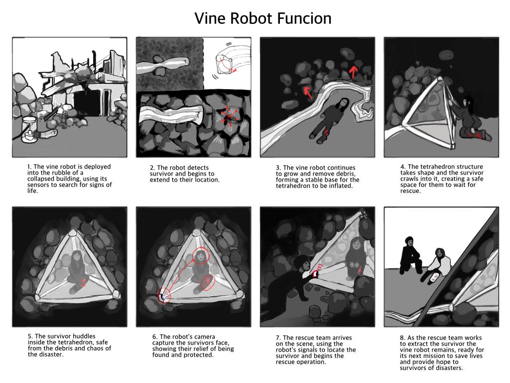
This storyboard above depicts the use of the vine robot. Here, it can be seen that the vine robot maneuvers through the rubble of a collapsed building. With the strength of xxx plastic, it is able to withstand potential tears occurring from sharp edges of debris. With the ‘muscle’ tubes, the vine robot can change direction, depending its own interest, which in this case is to locate and find a survivor. Initially, the vine robot would move randomly within the rubble. Once a survivor is located, the ‘muscle’ tubes can be set into action, allowing the vine robot to navigate its own path. Once it has successfully reached the survivor, air pressure of the tubes would remove any debris off the survivor. Then, it inflates into a tetrahedron shape, allowing the survivor to crawl within in order to keep them safe from being crushed by other debris. The camera within this structure can visualize any injuries of the survivor and send this live data to the rescuers outside. Once a rescue plan has been made, the rescuers can start moving their way to the survivor and rescue them from under all the rubble.
Primary Research
Query:
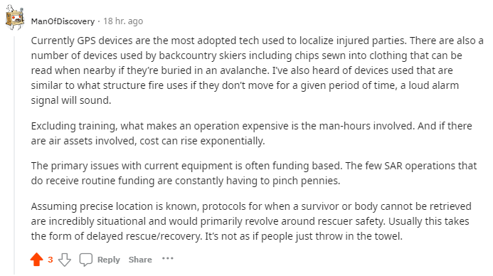
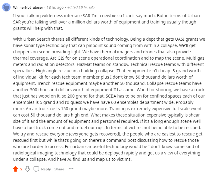
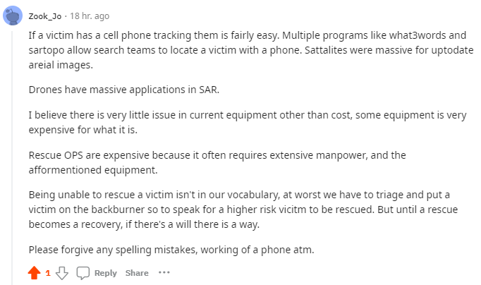
I am currently doing a project about technology being used in search and rescue situations. As a group, we have come up with some questions. These questions are here to give us an idea on areas which can be improved, such as the problems with current equipment. If you have contact with other SAR organizations, we would be grateful if you can help us get into contact with them, so that we can further our analysis. Thank you all in advance!
- What type of sensors/technology are currently used to localize a survivor?
- What are the main issues with the current equipment or what do they lack in?
- What makes a rescue operation expensive?
- What are some protocols for when a survivor cannot be rescued?
Answers:
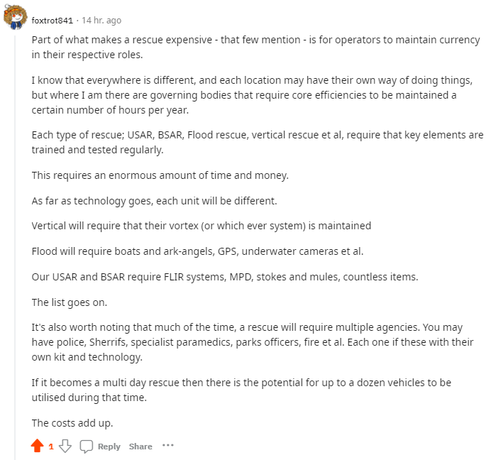
Localization
Current Difficulties
Earthquakes are one of the most devastating natural disasters, causing widespread destruction and loss of life. One of the biggest challenges that emergency responders and aid organizations face in the aftermath of an earthquake is localizing victims. This task can be extremely difficult due to a variety of factors, including the scale of the disaster, the nature of the terrain, and the complexity of the affected infrastructure.
Firstly, the scale of the disaster is often overwhelming, making it difficult for rescue teams to quickly locate and reach those in need of assistance. Earthquakes can cause extensive damage to buildings, roads, and other infrastructure, which can make it challenging for rescue teams to navigate the affected areas. Additionally, earthquakes can cause landslides, debris flows, and other hazardous conditions that can further impede rescue efforts.
Secondly, the nature of the terrain can also make it difficult to localize victims after earthquakes. Many earthquakes occur in mountainous or hilly areas, which can be challenging for rescue teams to access. These areas may have steep slopes, narrow paths, and other obstacles that can make it difficult to reach victims. Additionally, earthquakes can cause landslides and rockfalls, which can further complicate rescue efforts.
Thirdly, the complexity of the affected infrastructure can also pose challenges for rescue teams. Earthquakes can damage roads, bridges, and other infrastructure, which can make it difficult for rescue teams to access affected areas. In addition, damage to communication networks can make it difficult for rescue teams to coordinate their efforts and share information about the location of victims.
Lastly, the timing of earthquakes can also complicate rescue efforts. Earthquakes can occur at any time, day or night, and may cause power outages, making it difficult for rescue teams to operate in the dark. Additionally, aftershocks can further damage infrastructure and create additional hazards, making it difficult for rescue teams to work safely.
In conclusion, localizing victims after earthquakes is a challenging task that requires extensive planning, coordination, and resources. The scale of the disaster, the nature of the terrain, the complexity of the affected infrastructure, and the timing of the earthquake can all pose significant challenges for rescue teams.
Sensors and pathplanning
Colas et al. (2013) present a pathplanning that works for a 3D terrain. The system makes use of exteroceptive sensors, it uses a front-mounted rolling laser scanner that can take full three-dimensional (3D) scans of its surrounding. "This system is based on point cloud data and does not attempt to fully reconstruct the environment, but instead uses lazy tensor voting to assess traversability." Tensor voting means that it extracts geometrical primitives and saliency by voting of points So far, this system has been implemented for static environments, in dynamic environments it still has challenges. Which raises the question if our robot should be able to pathplan in a dynamic environment and if this is usefull for our robot.
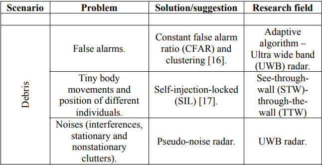
When we look at the table provided we see use cases of how to detect people under debris, with the current technologies and how to continue research into them. Ferrara V. (2015), explains everything in the paper regarding the shortcomings and benefits of each solution. Giving us a good start to figure out what technologies we need to research. Provided below is some information about them, but each would need to be researched in depth. I think for the current project idea, one of the following would be enough to deepen in as the full research into one of these would already take too much time.
CFAR
Constant false alarm rate (CFAR) detection refers to a common form of adaptive algorithm used in radar systems to detect target returns against a background of noise, clutter and interference. 1
An important CFAR algorithm is the cell averaging (CA) CFAR, in which the mean background level is estimated by averaging the signal level in M neighboring range cells.
SIL
The SIL radar is operated at 433 MHz ISM band to achieve excellent penetration capability and coverage. Moreover, an additional phase shifter is utilized to eliminate the large frequency shift, which is caused by strong clutter signals and often causes the SIL mechanism to fail.
UWB
UWB has traditional applications in non-cooperative radar imaging. Most recent applications target sensor data collection, precise locating, and tracking. Ultra low-power radio-frequency identification (RFID) tag with precision localization is often the enabling technology for location-aware sensor applications. Impulse-Radio Ultra-Wideband (IR-UWB) is a promising technology to fulfill the usage requirements in indoor cluttered environment. This doesn't specifically mean that it will work well under interference or rubble for that matter, but it does show us some promising results.
Weekly breakdowns
| Name | Total | Breakdown week 1 |
|---|---|---|
| Clinton Emok | 3h | Meeting (1h), literature research (1h), user definition(1h) |
| Richard Farla | 4h | Brainstorm session (1h), meeting (1h), literature research (1h), milestones (1h) |
| Yash Israni | 3h | Meeting (1h), user requirements(1h), literature research (1h) |
| Tessa de Jong | 4h | Brainstorm session (1h), meeting (1h), problem statement (1h), literature research (1h) |
| Kaj Scholer | 4h | Brainstorm session (1h), meeting (1h), milestones (1h), literature research (1h) |
| Pepijn Tennebroek | 4h | Brainstorm session (1h), meeting (1h), problem statement (1h), literature research (1h) |
| Name | Total | Breakdown week 2 |
|---|---|---|
| Clinton Emok | 5h | Meeting 1 (2h), Meeting 2 (2h), Meeting 3 (1h) |
| Richard Farla | 6h | Meeting 1 (2h), Meeting 2 (2h), Research equipment + how to build (2h) |
| Yash Israni | 7h | Meeting 1 (2h), Meeting 2 (2h), Meeting 3 (1h), Sensors (2h) |
| Tessa de Jong | 7h | Meeting 1 (2h), Meeting 2 (2h), Meeting 3 (1h), Literature research (2h) |
| Kaj Scholer | 10.5 | Meeting 1 (2h), Meeting 2 (2h), Meeting 3 (1h), CAD Modelling (2h), Storyboard (2.5h), Primary Reddit Research (1h) |
| Pepijn Tennebroek | 7h | Meeting 1 (2h), Meeting 2 (2h), Meeting 3 (1h), Fix literature (1h), Research Pathplanning (2h) |
| Name | Total | Breakdown week 3 |
|---|---|---|
| Clinton Emok | Meeting 1 (2h), Meeting 2 () | |
| Richard Farla | Meeting 1 (2h), Meeting 2 () | |
| Yash Israni | Meeting 1 (2h), Meeting 2 () | |
| Tessa de Jong | Meeting 1 (2h), Problem statement and Users (3h), Meeting 2 () | |
| Kaj Scholer | Meeting 1 (2h), Meeting 2 () | |
| Pepijn Tennebroek | Meeting 1 (2h), Problem statement and Users (3h), Meeting 2 () |
References
AJLabs. (2023). Infographic: How big were the earthquakes in Turkey, Syria? Earthquakes News | Al Jazeera. https://www.aljazeera.com/news/2023/2/8/infographic-how-big-were-the-earthquakes-in-turkey-syria
Blumenschein, L. H., Coad M. M., Haggerty D. A., Okamura A. M., & Hawkes E. W. (2020). Design, Modeling, Control, and Application of Everting Vine Robots. https://doi.org/10.3389/frobt.2020.548266
Coad, M. M., Blumenschein, L. H., Cutler, S., Zepeda, J. A. R., Naclerio, N. D., El-Hussieny, H., Mehmood, U., Ryu, J., Hawkes, E. W., & Okamura, A. M. (2020). Vine Robots: Design, Teleoperation, and Deployment for Navigation and Exploration. https://arxiv.org/pdf/1903.00069.pdf
Urban Search and Rescue Team. (2023). Update zaterdagmiddag. USAR. https://www.usar.nl/
Zepeda, J. A. R. (2022). The 1-minute vine robot. Vine Robots. https://www.vinerobots.org/build-one/the-simple-vine-robot/
Zotomayor, C., (2021). This Vine Robot Is an Unstoppable Force With Tons of Applications. https://www.solidsmack.com/design/vine-robot/
F. Colas, S. Mahesh, F. Pomerleau, M. Liu and R. Siegwart, "3D path planning and execution for search and rescue ground robots," 2013 IEEE/RSJ International Conference on Intelligent Robots and Systems, Tokyo, Japan, 2013, pp. 722-727, doi: 10.1109/IROS.2013.6696431. This paper presents a pathplanning system for a static 3D environment, with the use oflazy tensor voting.
Tai, Y.; Yu, T.-T. Using Smartphones to Locate Trapped Victims in Disasters. Sensors 2022, 22, 7502. https://doi.org/10.3390/ s22197502
Da Hu, Shuai Li, Junjie Chen, Vineet R. Kamat,Detecting, locating, and characterizing voids in disaster rubble for search and rescue, Advanced Engineering Informatics,
Volume 42,2019,100974,ISSN 1474-0346, https://doi.org/10.1016/j.aei.2019.100974