Field Line predictor: Difference between revisions
No edit summary |
No edit summary |
||
| (One intermediate revision by the same user not shown) | |||
| Line 1: | Line 1: | ||
<p>The detection module needs a prediction module to predict the view that the camera on drone would have in each moment. Because the localization method does not use image processing and there is no need to provide data of camera view other than side lines, the line predictor block just provides data of visible side lines, visible to drone camera. </p> | <p>The detection module needs a prediction module to predict the view that the camera on drone would have in each moment. Because the localization method does not use image processing and there is no need to provide data of camera view other than side lines, the line predictor block just provides data of visible side lines, visible to drone camera. </p> | ||
<p> | <p> | ||
[[File:linePre.png]] | |||
The input of the drone from other modules and predefined parameters are: | The input of the drone from other modules and predefined parameters are: | ||
* Altitude of drone (From drone IMU) | * Altitude of drone (From drone IMU) | ||
| Line 12: | Line 14: | ||
</p> | </p> | ||
<math>A=\begin{pmatrix} | <math> \ \ \ \ \ \ \ A=\begin{pmatrix} | ||
1 & 0 & \rho_1 & \theta_1 \\ | 1 & 0 & \rho_1 & \theta_1 \\ | ||
1 & 0 & \rho_2 & \theta_2 \\ | 1 & 0 & \rho_2 & \theta_2 \\ | ||
| Line 18: | Line 20: | ||
1 & 0 & \rho_4 & \theta_4 | 1 & 0 & \rho_4 & \theta_4 | ||
\end{pmatrix}</math> | \end{pmatrix}</math> | ||
<p>In this block the output coordinates (Rho and Theta) are same as Matlab Hough transform coordinate system. </p> | <p>In this block the output coordinates (Rho and Theta) are same as Matlab Hough transform coordinate system. </p> | ||
Latest revision as of 10:21, 1 April 2016
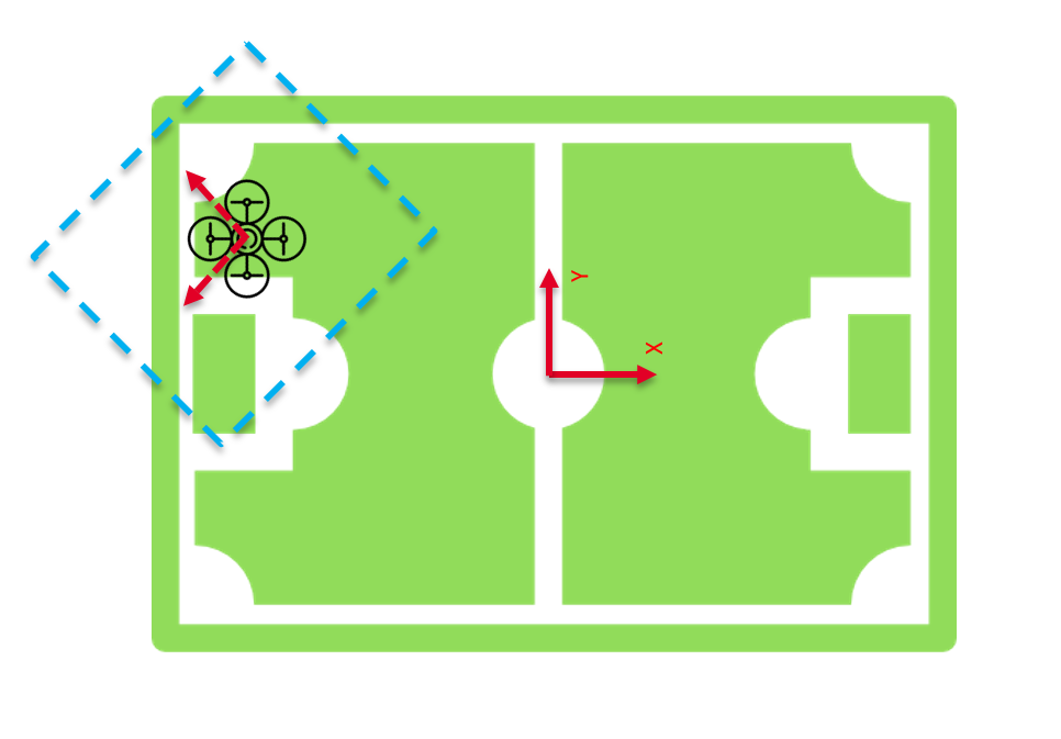
The detection module needs a prediction module to predict the view that the camera on drone would have in each moment. Because the localization method does not use image processing and there is no need to provide data of camera view other than side lines, the line predictor block just provides data of visible side lines, visible to drone camera.
 The input of the drone from other modules and predefined parameters are:
- Altitude of drone (From drone IMU)
- Drone position (From Localization block)
- Camera vision angle (Predefined)
- Yaw angle of the drone ( Sensor Fusion or IMU block)
The angle of vision of the camera is adjustable so that the module can be reused by different kinds of cameras. The output of the module is a 4 by4 matrix that each row is correspondent to each side line. The side lines are named from 1 to 4 (A11 , A12 , A13 , A14 ) . Second column gives information about visibility of line for drone camera. If 1, visible and if 0 not in camera range. Two last columns, ρ and theta, are line coordinates in Hough coordinate system.
[math]\displaystyle{ \ \ \ \ \ \ \ A=\begin{pmatrix} 1 & 0 & \rho_1 & \theta_1 \\ 1 & 0 & \rho_2 & \theta_2 \\ 1 & 0 & \rho_3 & \theta_3 \\ 1 & 0 & \rho_4 & \theta_4 \end{pmatrix} }[/math]
In this block the output coordinates (Rho and Theta) are same as Matlab Hough transform coordinate system.