PRE2024 3 Group10
The OneDrive can be accessed via https://tuenl-my.sharepoint.com/:f:/g/personal/l_kirkels_student_tue_nl/Ev3UBVOtfktApfNvxowBf-YBFpdR1uAtqIWQzg_Px7CosQ?e=URlCi2
Every week we have divided the task between chairman, minute taker and a wiki updater. The wiki updater updates the OneDrive at the end of the week to the Wiki page. Our group consists out of:
| Member | Student number | Program |
|---|---|---|
| Loes Kirkels | 1898477 | Applied Physics |
| Joost Schuurmans | 1893297 | Applied Physics |
| Jamin van Amelsvoort | 1829998 | Applied Physics |
| Tom Weegels | 1883410 | Applied Physics |
| Norah Bouma | 1902121 | Applied Physics |
Introduction: State of the art
The use of drones for detecting plastic waste on beaches, particularly under challenging weather conditions and during winter months, has been gaining increasing attention. Recent studies have demonstrated that drones equipped with advanced image processing algorithms can effectively contribute to the identification and classification of litter.
A relevant study conducted by Vallendar explored the feasibility of automating the detection of floating plastic waste in waterways using deep learning algorithms, specifically convolutional neural networks (CNNs). Although this study focused on waterways, the findings provide valuable insights applicable to beach environments. The researchers collected images under various conditions and utilized models such as DenseNet121, ResNet50, and InceptionV3. The best result was achieved with DenseNet121, with an accuracy of 87.6% for multi-class classification of plastic waste. By applying majority voting across the three best-performing models, accuracy improved to 91%. https://repository.tudelft.nl/
Another relevant development is the collaboration between the Royal Netherlands Sea Rescue Institution (KNRM), KPN, and TNO, where drones were deployed for detecting drowning victims along the Scheveningen coast. During these tests, drones were equipped with high-resolution cameras and thermal imaging cameras, using 5G connectivity for real-time image transmission. The collected images were analyzed to develop software capable of automatically detecting drowning individuals. This technology and approach could potentially be adapted for detecting plastic waste on beaches. https://www.tno.nl/nl/
A comparative study on litter detection using deep learning evaluated various object detection methods on datasets such as PlastOPol and TACO. Results showed that YOLO-v5-based object detectors performed best, with an AP50 score of 84.9 on PlastOPol and 63.3 on TACO. These findings highlight the potential of advanced deep learning models for effective litter detection.
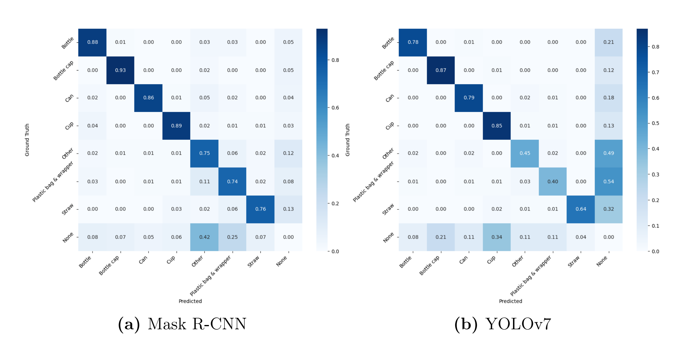
This paper investigates multiple AI learning models on the TACO dataset, which is a database consisting of all kinds of different plastics. They look at three different CNN (Convolutional Neural Network) algorithms, Mask Region-based Convolutional Neural Network (Mask R-CNN), You Only Look Once (YOLOv7), and U-Net, they then use two different machine learning models on these, k-Nearest Neighbors and Logistic Regression, were trained and evaluated. How this roughly works is that you have a dataset, in this case the TACO database consisting of images of all kinds of plastics. The CNN algorithms break down these pictures into very small pieces and look for similarities. These are mostly used for breaking down these pictures which are then classified with a different machine learning algorithm. Now you have classified a lot of pictures and if you use this trained model on a totally new picture it should be able to classify this new picture into one of the classes created by the machine learning algorithms. Their findings are that firstly the TACO dataset is quite imbalanced, favouring some types of plastic a lot more than others, a lot of pictures of cigarettes and plastic bags/wrappers, while straws, styrofoam and aluminium foil are very limiting. The confusion matrices of the trained models with Mask R-CNN and YOLOv7 can be seen below. The ones in the diagonal row from top left to bottom right, are correctly classified objects of a specific class.
An example of how the model detects plastic can be seen below, this is the YOLOv7 trained model. Boxes are roughly put around the object, a class is assigned to them with some specific probability of it being correct based on the data it has been trained on. So, if we figure out what exactly we want to detect it can be solely trained on this specific aspect to be very good at this one thing. The k-NN trained model had a total accuracy of 64%, while being very good in detecting bottles (82%), and plastic film (74%). The logistic regression model had a overall accuracy of 73%. So the logistic regression model is much more balanced than the k-NN trained model.
(https://uu.diva-portal.org/smash/get/diva2:1899954/FULLTEXT01.pdf
They state that the current detection with these trained models is okay, but far from perfect. More types of different litter categories are needed with a lot more data for some categories, because the data is skewed right now. These studies illustrate the potential of drones combined with advanced AI models for detecting plastic waste on beaches, even under challenging conditions. However, it is crucial to use datasets that are representative of the specific environment and conditions of Castricum Beach to ensure the accuracy and reliability of detection.
Problem statement and Objectives
Beaches serve as vital ecological, recreational, and economic assets, yet they are increasingly compromised by plastic pollution. The accumulation of plastic waste on shorelines, estimated at 20-80 kg per kilometer, poses significant environmental challenges, affecting marine ecosystems and reducing the aesthetic and economic value of these coastal areas. If not addressed, plastic pollution can lead to long-term ecological degradation and economic setbacks for coastal communities reliant on tourism and fisheries.
Efforts to mitigate this issue have primarily relied on organized beach cleanup initiatives, such as the Boskalis Beach Cleanup Tour, which mobilizes volunteers to remove plastic waste along the Dutch coastline. These initiatives also contribute valuable data concerning the quantity, type, and distribution of plastic waste. However, as these efforts predominantly take place during the summer months under favorable weather conditions, the data collected presents a skewed representation of the extent of plastic pollution. Seasonal variations, storm-driven plastic accumulation, and tidal influences are not adequately captured, leading to an incomplete understanding of the pollution problem.
Recent research in collaboration with Tako Popma has revealed that most cleanup efforts occur during the summer months, particularly in good weather conditions. However, Stichting de Noordzee has recognized the potential to extend cleanup activities into the winter months. During this period, larger debris such as fishing nets and broken plastic fragments are more frequently washed ashore due to the increased intensity of ocean currents and tidal forces. These large pieces can become quickly buried under sand due to strong winds, making it significantly harder for volunteers to detect and remove them. Unlike smaller plastic waste, which is often collected through traditional volunteer-driven cleanups, these large pieces require more strategic and timely intervention to prevent their long-term accumulation and environmental impact.
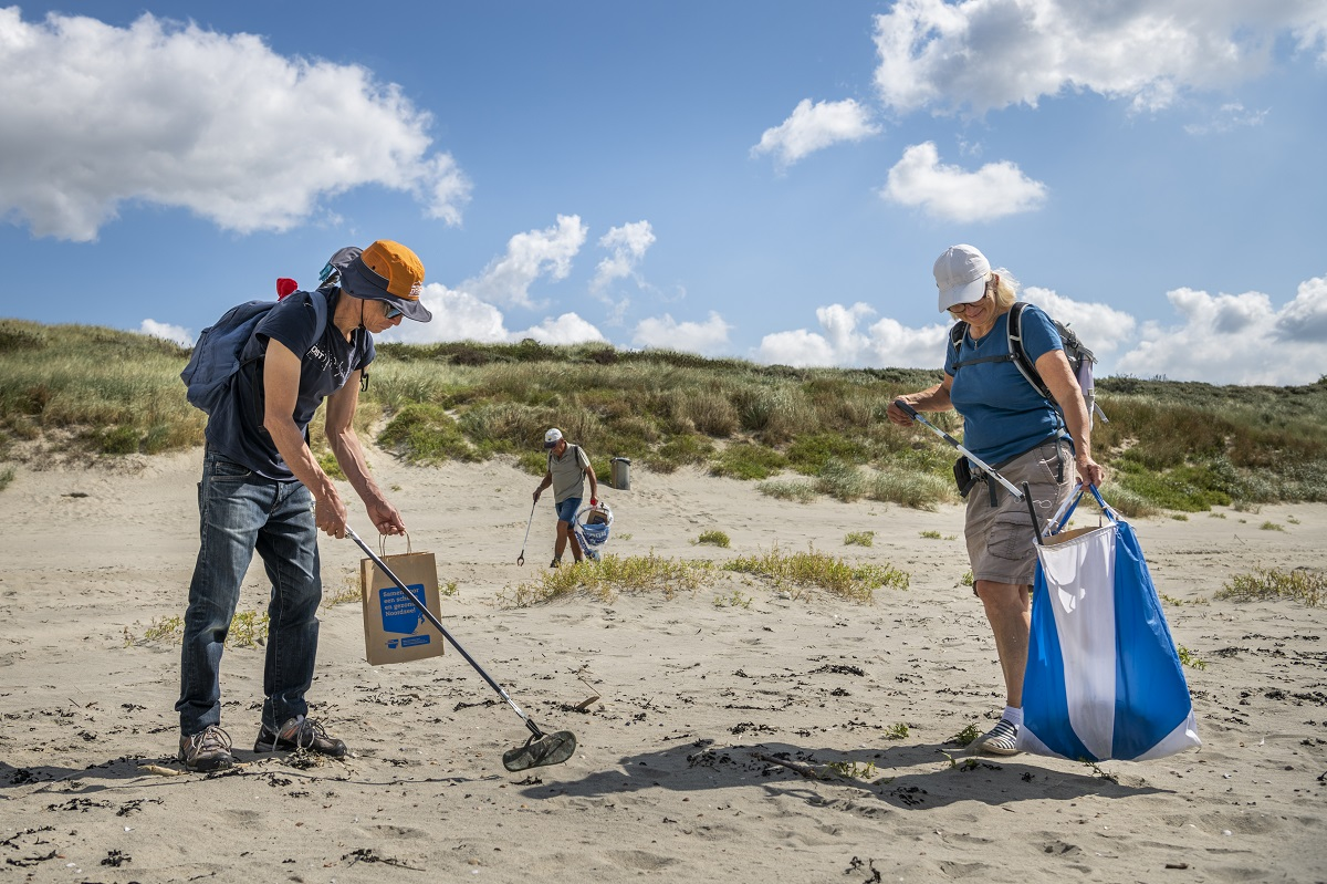
Stichting de Noordzee is required to conduct at least two surveys per year to assess the amount and types of plastic pollution on the beaches. However, out of their own interest and dedication to marine conservation, they currently conduct at least four surveys annually. These additional studies have confirmed the presence of large plastic debris on the beach, highlighting the necessity for more effective detection and removal methods. The winter months, in particular, present unique challenges as the stronger waves and tidal shifts transport heavier and bulkier waste to the shore. If left unaddressed, this waste can degrade into smaller microplastics over time, further exacerbating marine pollution and harming marine biodiversity.
A potential solution to this challenge is the implementation of robotic technology to improve data collection and enable more precise tracking of plastic pollution, particularly during the winter months when traditional monitoring efforts are less effective. Autonomous robots equipped with advanced sensors and imaging technology could help map the accumulation of plastic waste in real-time, providing researchers with a clearer and more continuous understanding of pollution patterns throughout the year. This would create a more accurate and comprehensive dataset that accounts for seasonal variations and environmental changes, offering policymakers and conservationists a more precise understanding of the pollution landscape.
The core focus of this research is to develop a robotic system capable of detecting and mapping plastic debris before it becomes buried under sand by strong winds. By leveraging AI-driven image recognition and sensor technology, robots can not only locate but also classify different types of waste, distinguishing between natural debris and human-made pollution. This enhanced data collection would allow for a more strategic approach to cleanups, optimizing resource allocation and improving the efficiency of removal operations. Furthermore, this system could serve as an early warning mechanism, alerting conservation groups and volunteers to high-risk areas before significant pollution buildup occurs.
In developing this robotic solution, various technical and operational challenges must be considered, including sensor accuracy, adaptability to harsh weather conditions, and the ability to function autonomously in dynamic coastal environments. The technology must be capable of operating effectively in strong winds, shifting sands, and fluctuating tides. The choice of sensors and imaging technology will be crucial in ensuring accurate detection of large plastic waste, even when partially buried. AI-driven image recognition models will need to be trained to distinguish between different types of waste, reducing false positives and optimizing cleanup efforts.
While sustainability, costs, and ethics remain important considerations, they are secondary to the primary goal of improving data collection and year-round monitoring of plastic pollution. Efforts will be made to ensure that the robotic system operates efficiently with minimal environmental impact, remains cost-effective, and is integrated in a way that supports rather than replaces volunteer-driven efforts. By addressing these factors, this research aims to create a scalable and adaptable robotic solution that enhances pollution tracking and mitigation on Dutch beaches, reinforcing the efforts of marine conservation organizations and policymakers in preserving coastal ecosystems.
Users and their needs
The primary user is Stichting de Noordzee which is an organization that specializes in cleaning the North sea in the Netherlands, including the beaches. They need a lot of data, over all periods, to get the full picture of the types of plastic, where exactly they are, in which time periods, etc. We have been in contact with them via mail, and are conducting an interview on the 10th of March. In this interview we want to get to know what they are currently doing, and what exactly they need, so maybe focus on a specific type of plastic, a specific weather condition, a specific period of time, etc. After this interview even deeper research will be done in specific elements of a solution of plastic data gathering in bad weather conditions. The interview can be found under 'Interview Stichting the Noordzee'
Primary users:
1.Stichting de Noordzee (The North Sea Foundation)
Stichting de Noordzee is a key environmental organization focused on preserving the North Sea and its coastlines. They are responsible for beach cleanup efforts, including large-scale initiatives such as the Boskalis Beach Cleanup Tour. To effectively combat plastic pollution, they require comprehensive and year-round data on plastic waste, including:
- The types of plastic found on beaches.
- The precise locations where plastic accumulates.
- Seasonal variations in pollution levels.
- The impact of weather conditions (e.g., storms, tides) on plastic accumulation.
Their primary need is a solution that enables reliable plastic detection and removal, even in challenging weather conditions when manual cleanup is difficult.
2. Beach Cleanup Volunteers and Teams
Volunteers play a significant role in organized cleanup efforts, but their work is limited by time, weather, and accessibility. A robotic system capable of autonomously detecting and removing plastic waste would assist these groups by:
- Reducing the manual workload required for beach cleanups.
- Operating in harsh weather conditions where human volunteers may be unable to work.
- Providing real-time data on plastic waste distribution to enhance planning and efficiency.
Their needs include a user-friendly and cost-effective solution that can be integrated into existing cleanup efforts without requiring extensive technical knowledge.
Secondary users:
1. Researchers and Scientists
Academic and environmental researchers studying plastic pollution, marine ecosystems, and AI-based detection technologies could benefit from the data collected by the autonomous system. Their key requirements include:
- Access to structured datasets on plastic pollution trends over time.
- Insights into how weather and tidal conditions influence plastic accumulation.
- Information on the effectiveness of AI models in detecting different types of plastic.
This research could contribute to a better understanding of plastic pollution patterns and inform future scientific studies.
2. Engineers and Technology Developers
Robotics engineers, AI specialists, and environmental technology developers could leverage the findings of this study to improve existing robotic cleanup solutions or create new ones. Their needs include:
- Detailed technical documentation on sensor performance and detection accuracy.
- Data on the environmental challenges faced by autonomous robots operating in beach conditions.
- Feedback on AI model effectiveness in real-world scenarios.
This information would help refine robotic designs, enhance AI detection models, and optimize system reliability.
3. Policymakers aMOSnd Government Agencies
Local, regional, and national government agencies responsible for environmental protection and waste management could use the research findings to support policy decisions. Their key requirements include:
- Reliable data on plastic pollution levels to justify funding cleanup initiatives.
- Evidence-based recommendations for integrating autonomous solutions into environmental policies.
- Compliance with national safety and environmental regulations for deploying robotic systems in public areas.
The success of an autonomous robotic cleanup system could influence future regulations on beach maintenance and contribute to the development of new standards for plastic waste management.
MOSCOW
Must
- Withstand constant wind speeds of 30-40 km/h (DONE)
- Withstand gusts of wind up to 90 km/h (https://www.weerplaza.nl/nederland/castricum-aan-zee/7727/klimaat/wind/?maand=feb) (Not fully possible)
- Able to fly in fog, when lights or objects are not visible from a distance of 1000 m (https://www.knmi.nl/kennis-en-datacentrum/achtergrond/mist) (DONE)
- Withstand a humidity of 87%, the average of December (https://www.weerplaza.nl/nederland/castricum/7726/klimaat/vochtigheid/) (Decreases battery, DONE)
- Able to fly in light rain, less than 1 mm per hour (DONE)
- Able to fly in darker days (DONE)
- Detect the location of plastics larger than 5 cm and identify the type of plastic using AI (DONE)
- Friendly to nature and animals (At 50m not a lot flies, but they can go down, so needs to be more considered)
- Map the entire beach of Castricum with a maximum of 2 batteries (Possible, but heavily depends on camera, DONE)
- Privacy friendly (Needs more research)
Should
- Map the entire beach of Castricum during its battery life
Could
- Waterproof
- Able to identify plastics in heavy fog (less than 200 meters visibility) (https://www.knmi.nl/kennis-en-datacentrum/achtergrond/mist)
- Able to fly during a heavy rain (3-10 mm in one hour) or in a downpour (more than 25 mm in one hour) (https://www.knmi.nl/kennis-en-datacentrum/uitleg/extreme-neerslag) (https://www.aaenmaas.nl/onswerk/leren-over-water/excursie-museumgemaal-caners/gemaal-caners/regenmeter-meet-hoeveel-mm-valt)
Won't
- Able to fly in a storm (average of 75-88 km/h in an hour) (https://www.knmi.nl/kennis-en-datacentrum/waarschuwingen/windstoten)
- Able to collect data during the night
- Able to collect the plastics that it finds
- Detect debris smaller than 5 cm
- Detect plastic in the sea
Innovation
To ensure the effectiveness of autonomous robotic solutions in beach cleanup operations, this study will explore several key technological components. An initial assessment of Castricum Beach will be conducted to evaluate the extent and distribution of plastic waste across different seasons. This will involve field studies to document pollution levels, identify sources of plastic waste, and analyze seasonal trends influenced by tidal activity and storm surges.
The study will also investigate AI-based plastic detection models to determine the most suitable approach for identifying and categorizing plastic debris in various environmental conditions. Deep learning models such as YOLO (You Only Look Once), Mask R-CNN (Region-based Convolutional Neural Networks), and U-net will be examined for their effectiveness in distinguishing plastic waste from natural materials. Consideration will be given to the trade-offs between accuracy, processing speed, and computational efficiency.
In terms of hardware, different imaging technologies will be evaluated for their suitability in detecting plastic waste under varying lighting and weather conditions. RGB cameras, thermal imaging, and hyperspectral sensors will be compared to assess their effectiveness in identifying plastic debris in wet, low-visibility, and high-reflection environments. LiDAR and depth-sensing technology will also be considered to improve object detection and classification accuracy.
Additionally, the study will explore the engineering challenges associated with deploying autonomous robots in beach environments, focussing on Castricum. These include mobility on wind, resistance to harsh weather conditions, and energy efficiency. (Various power sources, including solar panels and high-capacity batteries, will be analyzed to determine optimal solutions for sustained operation in remote coastal areas.)
Our idea and the current situation
In order for the design to work, it must be made sure that drones can fly in the weather conditions of the region we want to work, which is the Dutch coastal region. For this, a reference location of Castricum is taken. The weather conditions that are important for drone flyability are[1]:
· Temperature. Colder temperatures reduce the battery life of the drone.
· Rain. Of course, heavy rain can damage the electronics of the drone which is undesired.
· Wind. Drones should be able to fly steadily enough, even in wind. The general rule of thumb is that the wind speed should be no more than two-thirds of the maximum speed of the drone.
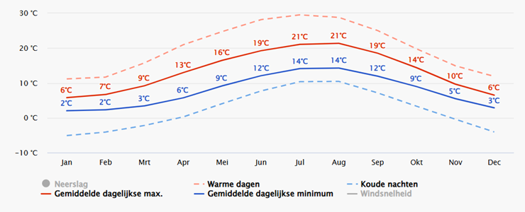
For the temperature, it was visible that the average temperature never reaches below 0°C, with the most extreme cold nights at -5°C [2].
In terms of rain, it was found that the maximum monthly rainfall does not exceed 80 mm in any month [2], equivalent to less than 2.5 mm per day on average.
The average, maximum and minimum wind speeds measured in Castricum are visible in figure 2 [3]:
As visible, although the wind speed can achieve maxima of 50 km/h, the average wind speed stays well below 40 km/h.
Can drones fly in these conditions?
To give answer to this question, two kinds of drones must be distinguished: The first of these are the common drones, which are the ‘standard’ drones which one could find everywhere. They are relatively inexpensive to purchase and easy to operate. Second, there are weather-resistant drones, which are better at handling heavy weather conditions, but are significantly more expensive than common drones [4].
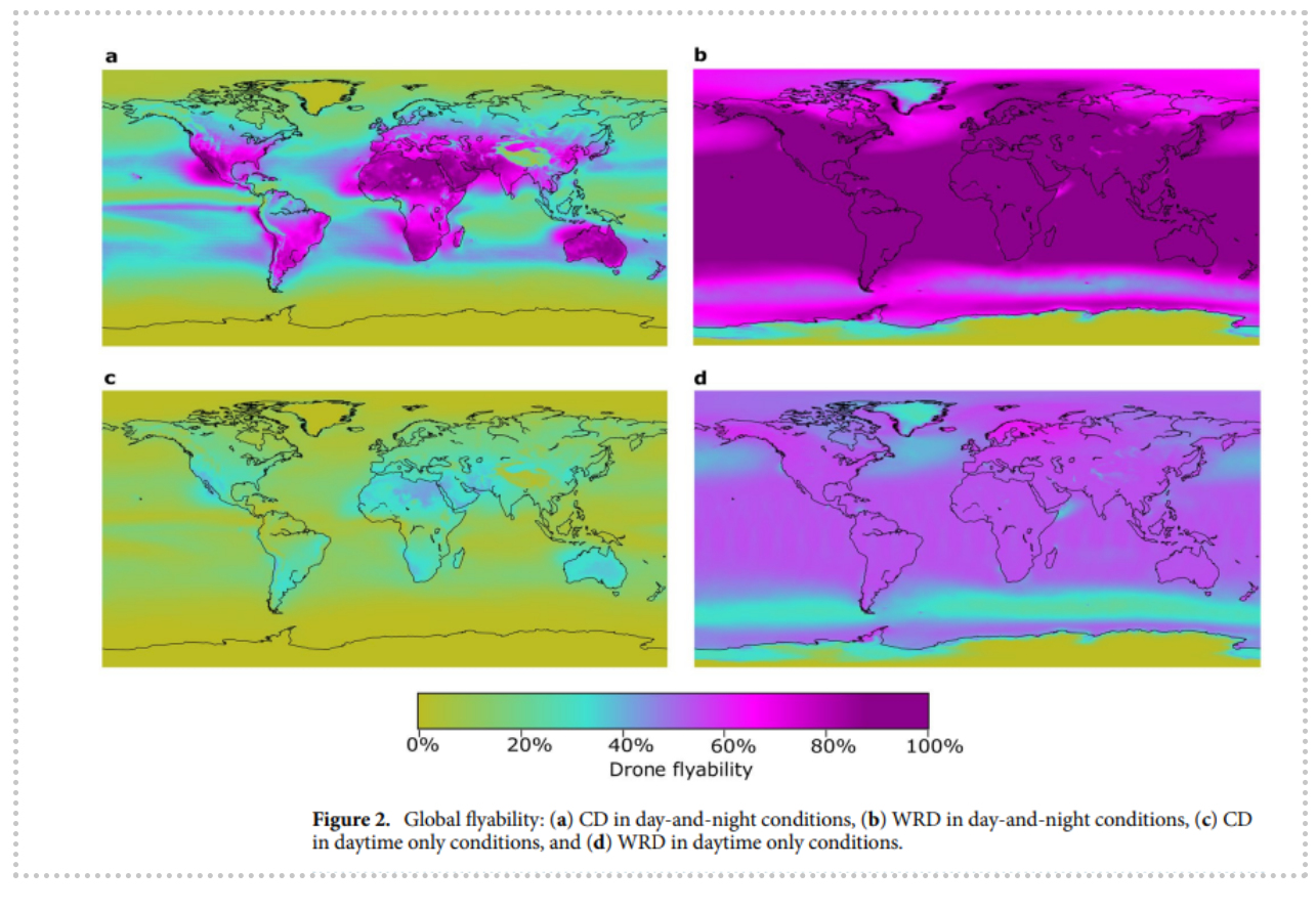
Common drones can fly in the temperature range of 0 to 40°C, can resist wind speeds up to about 35 km/h and cannot handle any rain.
Weather resistant drones, produced by for example company DJI, can operate in temperatures between -20°C and 45°C, resist winds up to 45 km/h and can often resist more than 10 mm rain per hour [4].
Looking at these values, it is clear that the expensive weather resistant drones can fly in the Dutch conditions mostly all of the time. Common drones however, have boundary conditions around the average weather conditions, meaning that the flyability of these drones depends heavily on the specific day.
Could drones fly in the direction of the wind to be more efficient?
A question that came to mind was whether the drones could fly in the same direction of the wind, to save energy. However, following from [5], it is stated that the average direction of the wind in Castricum varies a lot, making a systematic scan of the coastal region with this method very difficult. Of course, when the wind direction is in the desired direction, it is recommended to follow to wind direction to save energy.
Would land robots be better?
With this being said, it raises the question whether land robots would be a better option. Land robots have the advantage that they depend less on weather conditions, making them easier to manufacture and deploy in the wanted region. In addition, it is able to carry a load, which a drone cannot do.
However, land robots also have disadvantages in comparison to drones. Firstly, drones that are flying can scan way more land in a certain period of time than a land robot, making drones more efficient in the desired task of scanning beaches for plastics. Secondly, land robots are more noticable for humans and animals, possibly disturbing the calm beach site or getting damaged by an animal.
Conclusion:
Weather resistant drones are capable of flying in Dutch weather conditions almost all of the time. However, because of their expensive prices, these drones are not feasible for small scale companies. Common drones, which are less expensive, can only fly in the coastal region in certain periods of time, making their performance unreliable. Drones can scan more area for plastics in comparison to land robots, but land robots are more weather resistive.
Looking more at the weather in Castricum itself it can be seen that:
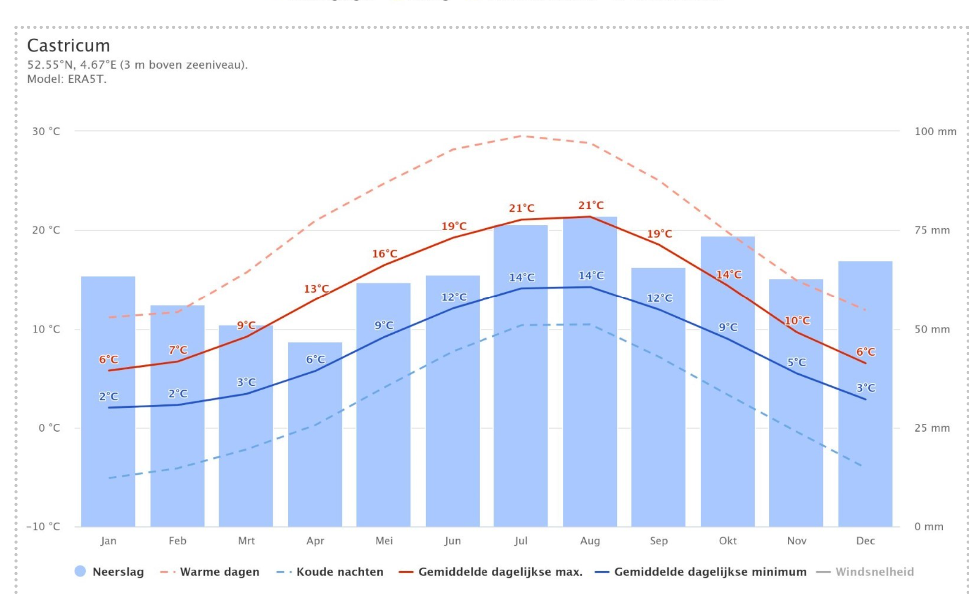
In the winter months it can get up to about -6 degrees celsius in the night, but on average the lowest will be about 2 degrees during the whole day.
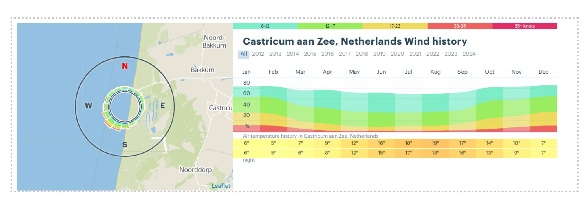
During the winter months, the wind speed can go up to about 35 knots or more, which is about 65 km/h or more, so that is very fast.. On average though the wind speed will be about 30-40 km/h.

All the plastic found during a cleanup on the Canticum beach is laid out here. The small pebbles are plastic pellets which are very small in size, about ten times maybe even more smaller than a cigarette bud, so very tiny. The rest are mainly broken pieces of plastic, cigarette buds, or other various types of plastic.
Suitable flight altitude and image resolution with GSD
The use of drones for garbage cleanup on Castricum beaches, particularly in poor weather circumstances, offers an option for effective and systematic waste disposal. Ground Sampling Distance (GSD) is a significant component in determining the effectiveness of drone-based litter identification.
GSD is an image resolution metric that calculates the real ground area covered by a single pixel in a picture. It is a key parameter in remote sensing, influencing the capacity to identify and classify items in a scanned area. The formula to calculate GSD is as follows,
GSD= H * Sw / (img * f), (1)
where,
- H = Flight altitude (m)
- Sw = Sensor width (mm)
- img = Image size (pixels)
- f = Camera focal length (mm)
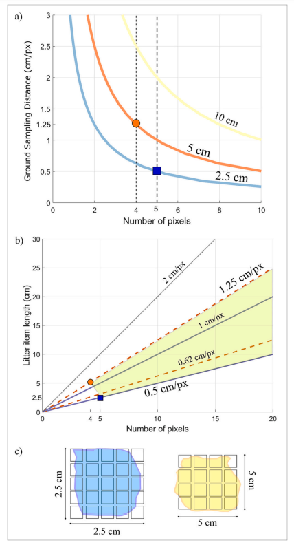
A lower GSD value increases image resolution, allowing for more exact identification of small waste particles. Studies have revealed that a GSD range of 0.5 cm/px to 1.25 cm/px is ideal for detecting and characterizing marine debris. At 0.5 cm/px, even small objects can be distinguished, whereas at 1.25 cm/px, larger waste items are visible but with less detail.
An image's detection capabilities is also affected by the minimum detectable item size, which may be calculated using,
Sz = Npx * GSD, (2)
where,
- Sz = Minimum detectable object size (cm)
- Npx = Number of pixels representing an object (typically between 4 and 5)
- GSD = Ground Sampling Distance (cm/px)
For example, if a piece of plastic garbage must be represented by at least 5 pixels for successful identification, a GSD of 0.5 cm/px can identify items as small as 2.5 cm. At a GSD of 1.25 cm/px, only objects larger than 6.25 cm can be effectively identified.
The choice of drone and camera combination is critical in obtaining the needed GSD. To retain the appropriate resolution range, drones such as the DJI Phantom 4 Pro, which is often used in aerial surveys, must operate at altitudes ranging from 18 to 46 meters. Higher-end professional drones with better cameras offer greater altitude freedom while maintaining high image quality.
To demonstrate the significance of GSD in drone-based litter identification, Figure 1a, 1b shows how GSD is determined. This diagram depicts the link between flight altitude, sensor width, and focal length, emphasizing the significance of choosing the appropriate drone settings for optimal data collecting.
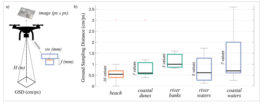
Additionally, Figure 2a,2b,2c demonstrates how different GSD values impact the detectability of waste items. It shows examples of items with sizes of 2.5 cm and 5 cm, illustrating how changes in resolution affect object visibility.
Finally, Figure 3a, 3b depicts an aerial view of a littered beach with various GSD values applied. The figure clearly indicates how raising the GSD diminishes the capacity to discern individual waste particles, making precise cleanup processes more difficult.
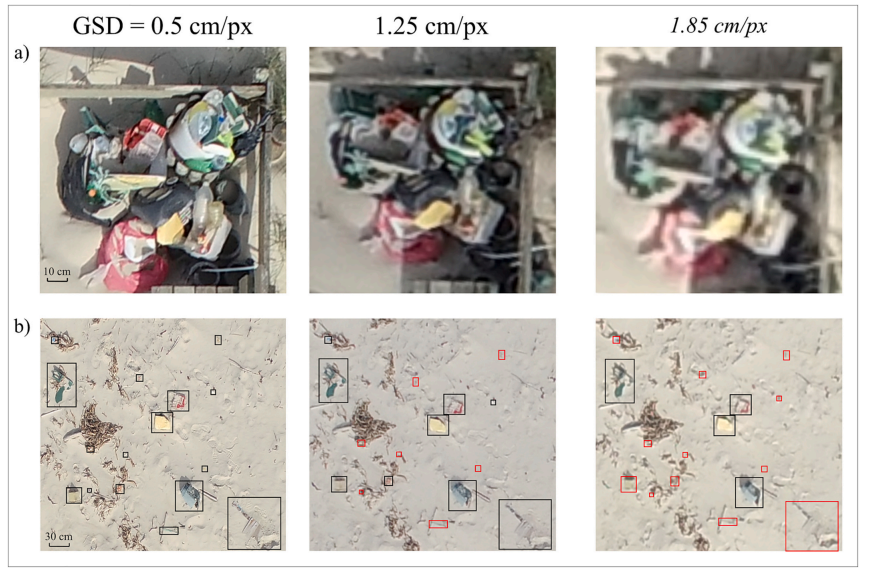
In practice, drone-based litter monitoring involves collecting photos with ideal GSD values, analyzing the images with object detection techniques, and mapping the distribution of garbage for targeted cleanup activities. This technology provides major benefits over typical manual surveys, including faster collecting data, larger area coverage, and increased accuracy in garbage identification.
Comparison of drones that are currently on the market
Castricum Beach in the Netherlands is known for its strong coastal winds and frequent rain, making it essential to choose a drone that can handle these elements. The next table compares some of the best drones for high winds and wet conditions, ensuring a stable and reliable flight even in challenging weather.
| Drone Model | Price (euros) | Wind Resistance (km/h) | Temperature range (degrees Celsius) | Waterproofness | General Use |
|---|---|---|---|---|---|
| Freefly Alta X | 18941 | 36 | -20 to 50 | IP43 (protection against water spray) | High-speed professional filming, industrial applications, cinematography, heavy-lift missions. |
| DJI Phantom 4 Pro | 1699 | 36 | 0 to 40 | Not waterproof | |
| DJI Matrice 350 RTK | 7999 | 43.2 | -20 to 50 | IP55 (Protection against low water pressure in all directions) | Industrial, surveying, and mapping, heavy-duty applications, emergency response, environmental monitoring. |
| DJI Mavic 3 Pro
https://www.dji.com/nl/mavic-3-pro/specs https://shop.autelrobotics.com/pages/evo-ii-pro-specification |
3099 | 43.2 | -10 to 40 | Not waterproof | Aerial photography, filmmaking, drone mapping, prosumer content creation, commercial inspections. |
| DJI Mini 4 Pro | 874 | 38.5 | -10 to 40 | Not waterproof | |
| Autel Robotics EVO II Pro
https://shop.autelrobotics.com/pages/evo-ii-pro-specification |
1925 | 61.2 | -10 to 40 | Not waterproof | Aerial photography, cinematography, surveying, commercial inspections, mapping, high-quality imaging. |
| SwellPro SplashDrone 4 | 2218.99 | 64.8 | -10 to 40 | IP67 (Fully waterproof, can float) | Fishing, marine work, search and rescue, rescue operations, rain-heavy environments, deliveries over water. |
| SwellPro Fisherman FD1 (No camera included)
https://store.swellpro.com/products/fisherman-max?variant=41033855402064 |
1408 | 64.8 | -10 to 40 | IP67 (Fully waterproof, can float) | Fishing, drone fishing, water-based tasks, marine environments, rain conditions, waterproof applications. |
| SwellPro Fisherman FD2 | 2647 | 64.8 | -10 to 40 | IP67 (Fully waterproof, can float) | |
| AgEagle eBeeX Mapping Drone | 17060 | 46 | Not specified | Not waterproof | |
| HoverAir X1 Pro | 549 | 38.5 | Not specified | Not waterproof |
The Matrice 350 RTK offers great wind resistance (up to 15 m/s) and an IP55 classification, making it suitable for flying in coastal breezes and light rain. However, for completely waterproof operations, the SwellPro SplashDrone 4 is the ideal alternative, as it has an IP67 classification and can land on water and fly in severe rain. The Freefly Alta X is the fastest and most wind-resistant drone, but it lacks waterproofing.
For robots with the goal to detect plastic on beaches, the following cameras and sensors can be used. They each have advantages or disadvantages for usage in bad weather conditions.
- RGB cameras
- Capture standard visual images and can be paired with AI-based image processing algorithms to recognize plastic waste. They identify plastic based on color, shape, and texture differences compared on the sand.
- Struggles in low lights when visibility is reduced, because the cameras rely on visual images.
- Multispectral and hyperspectral cameras
- Capture specific wavelengths of light beyond the visible spectrum. Due to this plastic can be distinguished from organic matter.
- Perform well under clouds but may be affected by wet weather, as moisture can alter spectral readings.
- Thermal infrared cameras
- Plastic absorbs and retains heat differently than natural materials. Thermal infrared cameras can notify these differences, thus differentiating the plastic.
- Effective in cold and cloudy conditions, because plastic does not retain heat from its surroundings.
Sensors:
- LiDAR (Light Detection and Ranging)
- Use laser pulses to map the terrain and detect objects in 3D. These type of sensors can be used by a robot travelling on the ground.
- Not effective in heavy rain or snow due to light scattering of the laser pulses.
- Near-Infrared (NIR)
- Analyzes the reflectance properties of materials, being able to differentiate plastic.
- Can be affected by wet surfaces
- Ultraviolet (UV) Sensors
- Take advantage of the fluorescence exhibited by some plastics under ultraviolet light.
- Laser-Induced Fluorescence (LIF) Sensors
- LIF uses a laser to excite plastic materials, causing them to emit characteristic fluorescence. This method is effective even under cloudy conditions since the laser provides its own illumination.
- Highly effective in low-light and cloudy conditions, as it uses an active laser source, making it one of the most reliable methods for detecting plastic in adverse weather.
Thus, for a robot that is used to detect plastics, it is best to use a thermal infrared camera with a sensor using Laser-Induced Fluorescence. With these combination, the camera contains images using heat, and observes the plastic using the fluorescence characteristics of plastic. Both of these are minimally affected by bad weather.
Fulfilling technical requirements
This part will be about the things that are needed to provide a drone that can survive in harsh winds and rain while also being able to detect.
Technical requirements
- Withstand constant wind speeds of 30-40 km/h and possible gusts of up to 90km/h (https://www.weerplaza.nl/nederland/castricum-aan-zee/7727/klimaat/wind/?maand=feb)
- Needs to be able to fly in rain, snow and hail.
- Camera should be able to see in fog, rain or darker days.
- Should be able to detect larger plastic of about 5 cm or bigger, depends on height and camera.
- Beach should most preferably be able to be mapped during its battery life
Cameras, drone height and battery life
Most drone cameras are not separately purchasable, they are built for that specific drone. The brand Zenmuse does have several separate drone cameras that can cost up to 3000 euros which have a 8K resolution and 80 degree field of view. We need a good resolution to get as high as a pixel/cm as possible, such that smaller plastic can be detected. Also a higher FOV leads to be able to see more of the beach in one image, which means that less images have to be taken, the drones mission will take less long. We want the drone to be able to complete its mission in one battery life, so both resolution and FOV have to be weighed against each other. The very best cameras like the Zenmuse X9-8K Air are 8k and have 80 degree FOV, but hey are only water resistant, not waterproof. Most waterproof drones like the Huntress series drones have 4k 70-80 FOV cameras. So for a minimal calculation of preferred height of the done to detect the plastic a 4k 70 FOV camera will be taken.
The beach of Castricum is about 5km long and 145 meters wide. Taking the camera with a FOV of 70 degrees and 4k resolution, at a height of 50m above the beach, you get about 1.9 cm/pixel, this way objects of 5cm and bigger can be detectable. A height of 50m is chosen because this is where wind speeds are measure on Castricum beach, so this data is very well known. If you go higher than 50m the wind speed will also be even higher. The focus lays on somewhat bigger plastic objects that will reenter the sea during storms, and continuously break down getting very small and ending up under the sand somewhere, making it difficult to find and clean. With this camera at this height these objects are easily detectable. Then taking an angle of 70 degrees and height of 50 m, you get a length on the beach of 70m. Then you have an image with a radius of 70m, so you need an overlap of images of about 10%, which leads to 180 images of the beach in total. You need two rows of images because 145/70 ≈ 2, this is 10km in total. High tier industrial drones as depicted in Table ???, can reach speeds of about 65km/h. We need good images, 180 times, so together with very heavy winds, let's say the drones go averaged out 20km/h, this means that all images have been taken in 30 minutes. These drones all have battery capacities of 45min-1 hour, with heavy winds and rain this worsens a bit though, but 30 min is probably still feasible. After this mission it has to charge up again, this can be done in one hour, which means it can then be sent on another mission. This means that taking a high tier drone with a camera like the Zenmuse H20N, 180 clear images can be taken in a time before the batteries are empty.
For AI detection, we need cameras at specific height and good enough resolution and FOV, such that pixel/cm can see plastic of >10cm, about 2 cm/pixel is needed for this, as then it is split up into about 8 pixels. Need to think about if you want to go higher for faster mapping of beach, or lower for slower but ecologically better. Birds mostly fly at heights higher than 100 meters, so lower than that would be better. Cameras with a resolution of 2K will be needed, which are usually around 100-200 euros and usually have a minimum FOV of 70 degrees. Most same resolution cameras are more expensive than one another due to higher FOV but most often due to better fps with videos, which is not a problem for us, as only pictures want to be taken. Videos could be good to retrace al the steps, but this will cost extra energy, decreasing battery life, costs more data, so less could be stored. Then you have 4k and 8k cameras which provide much sharper images but are much more expensive. They can go from 200-5000 euros, the ones from 1000 euros onward are equipped with extra equipment making them able to capture rapid fire images, much better frames per second and other neat tricks.
Taking the cheapest 2k cameras, with 70 FOV leads to a height of 25m for 2cm/pixel. At 25m 5 lengths of 5 km are needed, so 25km. This means that to get it within one battery lifetime it would not reach the end, so it should be charged once during its mission. Taking the best camera, at 50m, it would only take 30min on 20 km.h, which leads to longer battery lifetime, less charging, saving energy. Also, if it has to be charged, it will need to be charged by a person, taking more time.
Deraining of images.
There could be a problem with the images that are taken, because if it is raining, which is most probably is before and after storms, the images could be rained on, foggy or generally unclear. This can be fixed however with AI models that can very effectively derain images (https://ece.anits.edu.in/IV%20ECE%20C/C2.pdf and https://www.sciencedirect.com/science/article/pii/S0925231222008918).
As can be seen in the figure above, the right image is the derained version of the first one, and the bike can now be identified very well. This can be applied to our problem as well. There are also other models that can effectively demist images, like ones on foggy car windows. That can also be applied to our images leading to clear images from which plastic can be identified. This technology is also being improved at all times as it is a very important thing for for example self driving cars as well, that the cameras can see 'through' rain.
As can be seen above, a foggy image with AI object detection has been defogged with an algorithm which is then also been put through AI object detection. Due to the defogging much more objects are visible with a much higher accuracy, from 16% to 61%. With these types of AI algorithms pictures taken in bad weather conditions can be 'cleaned' up leading to much clearer images where the object can be detected.
AI Plastic detection
The most effective way to train an AI algorithm is to use the YoloV8 model, because it is the best open source AI learning model and train it with logistic regression on a specific litter dataset. The paper mentioned in the literature review states that the YoloV7 model gets a higher average accuracy, on some categories the Mask-RCNN trained AI is better, but on average YoloV7 was better. YoloV8 is an even stronger and faster model than the 7th version. A logistic regression trained model will be better because this also leads to a better overall accuracy of litter detection as compared to a k-nearest neighbours algorithm. Then the most important part is choosing an appropriate dataset on which the model will be trained on. There are multiple candidate datasets that include a lot of different litter, mostly plastic.
- TACO dataset: Contains 4700 different annotated objects divided into 60 different unique categories, and images keep getting added and annotated. Contains a bunch of different types of plastics on various backgrounds, which is good because the beach can look vastly different in different weather conditions.
- UAVVaste dataset: Contains 3700 different objects of drone images, so from the top, but they are not divided into any classes, they are lumped together as litter.
- BePLi v2 Dataset: Contains 3780 images of plastic litter only on beaches. They are lumped in as plastic, not divided into any categories.
We will choose for the TACO dataset as stichting de Noordzee wants to know what types ofplastic is on the beach, and this can most effectively be achieved by training a model on the TACO dataset. The 60 different categories offer a wide variety of different types of plastic which will be encountered on the beach. Stichting de Noordzee wants this data to map what specific type of plastic lands on the Dutch beaches during the colder months.
Social and environmental needs
Environmental problems
Effect of drones on animals near beaches
An important aspect of the drone is that it should not be affecting wildlife in negative way. It is known that drones may disturb wildlife, the source of that is mostly the sounds that they make. To know how disturbance of the wildlife in Castricum can be minimalized, it is important to know how the sound of drones affect animals.
It is known that birds will be most affected by drones when they are nesting, that is the period that they are most cautious. Also, being disturbed is more harmful for the birds when they are nesting, compared to when they are not nesting as they are leaving nests or chick unprotected https://camphikelivecalifornia.com/how-to-avoid-disturbing-wildlife-with-your-drone/.
That is why this research is conducted with breeding birds. It examined how many times the birds are disturbed as a response to the presence of a drone as this is the strongest reaction a breeding bird can have. Disturbance was defined as a bird moving off the nest, returning or not. This includes, but is not limited to, flushing, swimming away, or escape behavior https://journal.afonet.org/vol94/iss2/art3/.
The results of this research were that drone flights with an altitude larger than 50 m showed no evidence of disturbance on nesting birds. Conversely, flights at lower altitudes (≤ 50 m) showed stronger evidence of disturbance effects. The amount of disturbance by the breeding birds also depended on the type of nest the birds had. The largest odds of disturbance was observed on ground solitary and non-ground solitary nesters. Colonial nesters showed no evidence of disturbance, regardless of the drone altitude https://journal.afonet.org/vol94/iss2/art3/.
As a result of this research it is important to find out whether drones in Castricum will have an effect on breeding bird. For this a list of the birds that can be found in Castricum and their breeding properties is presented: https://www.birdingplaces.eu/nl/birdingplaces/netherlands/infiltratiegebied-castricum.
- Osprey (top of the tree, May-September) https://www.vogelbescherming.nl/ontdek-vogels/kennis-over-vogels/vogelgids/vogel/visarend
- Wheatear (on the ground, April-June) https://www.vogelbescherming.nl/ontdek-vogels/kennis-over-vogels/vogelgids/vogel/tapuit
- Kingfisher (in a tunnel underground, from February/March) https://www.vogelbescherming.nl/ontdek-vogels/kennis-over-vogels/vogelgids/vogel/ijsvogel
- Hawk (top of a tree, end of march until may) https://www.vogelbescherming.nl/ontdek-vogels/kennis-over-vogels/vogelgids/vogel/havik
- Tufted duck (besides the water on the ground, end of April until start of May) https://www.vogelbescherming.nl/ontdek-vogels/kennis-over-vogels/vogelgids/vogel/tafeleend
- Snipe (On the ground, April-June) https://www.vogelbescherming.nl/ontdek-vogels/kennis-over-vogels/vogelgids/vogel/watersnip
- Green woodpecker (In a hole in a tree, March-June) https://www.vogelbescherming.nl/ontdek-vogels/kennis-over-vogels/vogelgids/vogel/groene-specht
- Wild swan (Breed in the summer in warmer countries) https://www.vogelbescherming.nl/ontdek-vogels/kennis-over-vogels/vogelgids/vogel/wilde-zwaan
- Water rail (On the ground, March-August) https://www.vogelbescherming.nl/ontdek-vogels/kennis-over-vogels/vogelgids/vogel/waterral
- Bittern (On the ground, April-June)
In this list it can be seen that the bird that breeds the earliest in the year is the kingfisher. Which starts breeding in February. All the birds are out of their breeding season by September. Thus, if the drones won't be flying from February until September, the breeding birds will not be affected by them.
It is known that, in contrast to birds, wildlife living in the sea exhibit a lower probability of disturbance due to the presence of drones. https://www.researchgate.net/publication/381565718_Unveiling_the_Impact_of_Drone_Noise_on_Wildlife_A_Crucial_Research_Imperative. That is because the sounds emitted by drones do not propagate effectively from air into water. The resulting noise that can be heard underwater matches the background noise present in shallow water habitats.
Thus, breeding birds and marine life are not affected by the sounds of drones, which would be the largest source of concern in this case. For the other types of wildlife, such as non-breeding birds and land mammals, there are ways to avoid disturbances due to drones as much as possible. Firstly, it is advised to not use drones that resemble raptors. There are three types of drones, fixed wing drones, multirotor drones and Vertical Take-Off Landing (VTOL) drones, see image ?? https://www.researchgate.net/publication/381565718_Unveiling_the_Impact_of_Drone_Noise_on_Wildlife_A_Crucial_Research_Imperative. It is not recommended to use fixed wing or VTOL drones, as they resemble a raptor more than a multirotor drone, which has been found to increase disturbance in some species https://journal.afonet.org/vol94/iss2/art3/. Another way to avoid making birds think the drone is a predator is to avoid maneuvers that predators make. The drone should fly in straight lines, it should not move erratically or back and forth. Lastly, it is also logically recommended to keep the flights as short as possible and to take them at the highest possible altitude.
Solving of environmental problems caused by plastic on beaches
In the colder months less of the plastic is cleaned up. This means that a lot of plastic can build up on the beach during these months. Not often during these months, but some times the sun will come, which poses a big problem, being that because of this big buildup of plastic and the sun blasting light on it, the beach becomes very hot. This increase in temperature on the beaches is bad for animals on the beaches or birds that would land on the beach. Also during the night the beach will get even colder, leading to bigger thermal fluctuations. The heating of the plastic also leads to emission of greenhouse gases contributing to climate change (https://zerowasteeurope.eu/2020/09/no-time-to-waste-plastic-pollution-and-the-climate-crisis/). At about 25 degrees celsius the plastics consisting of polyethylene will produce methane which is an even worse greenhouse gas than carbon dioxide, but since it is in the colder months this effect will be limited, but still prevelant. By then effectively monitoring and cleaning the plastic on the beaches this can be partially avoided, increasing comfortability for the affected animals. (https://www.smithsonianmag.com/science-nature/plastics-make-beaches-hotter-during-day-and-colder-night-180978353/)
Another big problem caused by the large amounts of plastic on beaches, is the consumption of this plastic by various animals, mainly seagulls. About 90% of seabirds in the Netherlands are found with plastic in their bodies, without any solutions every bird will have eaten plastic before they die. Even though some of these birds migrate in the cooler months, a lot of the Dutch seagulls stay in the Netherlands near to the beaches. This means that if the beaches aren't also cleaned in the colder months, the seabirds are still susceptible to eating plastic. This disrupts the ecology of the seabirds, leading to less of them and destroying their lives. So, the occasional monitoring and cleaning of plastic on the beach will also increase comfortability of seabirds and other animals living on the beach by limiting the plastic they can consume. (https://www.vogelbescherming.nl/ontdek-vogels/kennis-over-vogels/vogelgids/vogel/zilvermeeuw#:~:text=Nederlandse%20zilvermeeuwen%20blijven%20vooral%20in,en%20Oost%2DEuropa%20ons%20land. and https://www.animalstoday.nl/zeevogels-eten-plastic-2050/)
At the beach of Castricum, the weight of the total litter varies depending on the season. There is not exact data of Castricum itself available, but there is a beach near it with similar circumstances. In January of 2022 it was the lowest with 3.2 kg per 100 meters, while in October it got up to 9.6 kg/100m. For 2023, January stayed the same, but in October there was the first monitoring action for individuals, which lead to there only being 1.4 kg per 100 meters. This shows that the monitoring and individual cleanup helps a lot. If the monitoring can be done by drone before any storm, the volunteers can be even quicker and the data can be more accurate. This data can be found in the annexes of the litter monitoring rapport[9].
Socio-economic impact
Cost Efficiency of Volunteers
To see how much can be gained from using drones for these purposes, a few things have to be looked at regarding the volunteers. During the summer actions of cleaning up the beach, the days usually last from 10:30 to 15:30 of cleaning. In total there are almost 21000 volunteers spread over 30 parts, but some beaches can host more volunteers than others. According to the Castricummer, they reached about 150 people for the beach of Castricum. This already a lot of time spent, which can be reduced if the whereabouts of the plastic is known.
The other way it can be compared to volunteers is through the monitoring program of stichting de Noordzee. This is also most likely a better comparison, since that the drone is mainly for monitoring. Two times per year, in March and October, there is a program where volunteers get their own part of a beach to investigate. There is a two week period when the volunteers can choose a full day to gather everything from their part of the beach. There is a toolkit given to them to learn what they need to do exactly. This part is from the sea until the dune and then 50 meters along the beach, which is about 1% of the entire beach. If there would be a drone in place, there would be no need for the volunteers to do the monitoring. And it would also be better, because not every part of the beach can be done now. The only issue is that the plastic will not be cleaned up yet, but it can be done faster if necessary, because it is known where everything is.
There are multiple people needed to maintain our drone solution. There is someone needed that can charge the drone whenever it has completed a mission, someone that can retrieve the drone after it has been blown away by wind and fallen in the sea or somewhere on the beach, also someone that analyzes the images of the drone and see how correct the AI model is and where needed annotating images where the detection model has failed. Lastly, there are ofcourse people needed to actually clean the plastic. The charging and retrieving of the drone could be done by the same person, who can also maintain and clean the drone if a lot of sand is on there for example. Also one person is needed to analyze the images, annotating them where needed and who notes the performance of the AI detection model. This person should keep annotating incorrect findings and big failures in the detection model to further improve it. To clean the beaches most probably 5-10 people would be needed to relatively quickly clean everything up. These people could most likely consist of only volunteers. This means that beach cleanups in these time periods could still be done quickly. This solution as opposed to one with a beach land robot is that more people are needed our solution, but hotspots of plastic can be located to heavily improve cleanups, and a proper dataset of the types of plastic in these weather conditions can be made.
Privacy
https://www.autoriteitpersoonsgegevens.nl/themas/cameratoezicht/drones/basisprincipes-voor-het-gebruik-van-drones-met-cameraWhen a drone captures people in a recognizable manner, it must comply with the General Data Protection Regulation (GDPR). The relevant principles of the GDPR are as follows:
- Personal data may only be processed if there is a valid reason for doing so. The GDPR outlines several justifications for processing personal data. In this case, the reason for using the drone is stated as follows: "The processing is necessary for the performance of a task carried out in the public interest or in the exercise of official authority vested in the controller."
- The necessity of deploying a drone must be clearly demonstrated. This assessment must take into account:
- Subsidiarity (the objective cannot be achieved by other means)
- Proportionality (the impact on privacy is proportionate to the purpose of the processing). The necessity of the drone has already been explained, along with why an alternative is insufficient.
- Cameras may not be used for longer, and no more people or locations may be filmed, than strictly necessary to achieve the intended purpose. It has already been argued that the drone will follow the shortest possible route and will not be used for more than neccessay.
- People who may be filmed must be informed about the use of drones with cameras before filming takes place. This can be done by placing signs at the edge of the flight area or by distributing informational brochures on-site.
Proposal for research and development
Conclusion and recommendations
In this report, the application of drones equipped with advanced imaging technology was researched, in combination with its social impacts. In this section, a brief overview is given, together with a final recommendation.
Technical insights:
· Drone selection: Combining the need for a wind- and water resistant drone, the most suitable variant on the market was found to be the SwellPro SplashDrone 4, being able to withstand wind up to 64.8 km/h and is fully waterproof. In addition, it can fly in temperatures between -10 to 40 °C, which should not lead to any issues on the Castricum beach.
· Camera:
. AI-systems: Up until now the best accuracy which has been achieved for detecting plastic on beaches from various angles is 78%. This is done with the YoloV7 model, trained with mask-RCNN algorithm on the TACO data set. The YoloV8 model is even better, but not available for regular use yet, but with sufficient government backing this could be achieved. A YoloV8 detection model will then be trained with a Mask-RCNN algorithm on the TACO dataset to ensure sufficient categories that detected plastic can be placed in, as the TACO set contains 60 different categories. Furthermore this system will be corrected by people and further improved.
Social insights:
· Costs against gains:
· Effects on wildlife: It was found that the usage of drones in the winter period does not have any negative impact on breeding birds or marine life.
· Privacy considerations: After considering the General Data Protection Regulation, it was found that, when we inform all beach guests about it, the usage of drones will not violate any privacy regulations
All things considered, this leads us to our final recommendation for Stichting de Noordzee:
We would highly recommend the usage of drones for detecting large-size debris along beaches before stormy periods. The research has shown that with the current market, there are possibilities to achieve a drone that handles the weather, and with the right camera, is able to detect large-scale waste on beach sides. This will not harm privacy regulations or wildlife around beaches. In addition, the scanning and analysis of the debris can be done quicker and with fewer volunteers, making the analysis more efficient and enabling more frequent monitoring to keep beaches cleaner. Lastly, by scanning the beaches before a storm, it is known where debris is placed on the beach, even when it gets covered by sand later. This makes for better cleanup actions after the data processing phase.
References
Planning and role of each student individually
| Approach | Milestones and deliverables | |
|---|---|---|
| Week 1 | -Make planning with milestones and deliverables (everyone)
-Literature study (5 articles per person), summarized on the wiki (state-of-the-art research) -Make problem statement and objectives (Jamin) -Write down users and what they require (Joost) |
Problem statements and objectives
Plan (subject, objectives, users) |
| Week 2 | -Make a state-of-the-art from the summarized articles (Norah)
-Think of the requirement and goals the robot should have (Loes&Tom) -Do further research (Everyone) -Try to look for organizations and try to contact them |
State-of-the-art
Concrete ideas for a concept |
| Week 3 | -Write down the research in the wiki (Everyone)
-Look to Castricum circumstances and if drones are realistic or if a landrobot better can used (Joost) -Look at robots on beaches and to bad weather conditions Castricum beach (Tom) -Look at current AI plastic detection and which would best be applicable (Jamin) -Look at research for cameras and sensors -Contact Noordzee and setting an interview, adapt the wiki (user + state of the art) and preparing a script for the interview (Loes) |
Finished research
Have a rough overview Contact with Stichting de Noordzee |
| Week 4 | -Summarize the whole interview (Tom)
-Look further into Castricum circumstances with the new knowledge of the interview, work out cameras and sensors (Norah) -Look at the qualifications of the robot (Joost) -Look at GSD, suitable flight hight and drones that are currently on the market, also adapt the wiki to the interview, update the planning (Loes) -Compare info from the interview and look at AI models for bigger pieces of plastic (Jamin) |
Research and results in the wiki
Interview Stichting the Noordzee summary |
| Week 5 | splitting up the group in two:
-Design concept -Finish the wiki |
Finalized concept
Finalization of research, everything written down in the wiki |
| Week 6 | -Make the presentation
-Room for things that still need to be done |
Presentation |
| Week 7 | Preparation for final presentation |
| Loes | Joost | Jamin | Tom | Norah | General | |
|---|---|---|---|---|---|---|
| Week 1 | Research papers (6h) | Research papers (4h) | Research papers (5h) | Research Papers (5h) | Research Papers (5h) | Monday morning lecture + discussion (2h), Wednesday morning working session (4h) |
| Week 2 | More specific research (4h),
Contacting different organizations (2h) |
Monday morning meeting (1h), monday afternoon meeting (4h), contact users (4h), generalize and research the subject (2h) | ||||
| Week 3 | Contacting stichting the Noordzee further (1h),
Preparing/ setting the interview with Stichting the Noordzee (2h), Changing/Expand the wiki (Users and problemstatement) (1h) Setting up the interview script (1h) |
Research drones in bad weather conditions (4h)
Updating wiki (1h) |
Reading papers and articles on AI detection models in general (3h)
Investigating various plastic databases (1h) Reading and summarizing paper on AI plastic detection models (3h) |
Researching weather conditions of Castricum (3h)
Researching kinds of plastic found at Castricum beach (2h) |
Monday morning meeting(1h), monday afternoon meeting (4h), research/contact organizations (1h) | |
| Week 4 | Have contact with stichting the Noordzee (1h)
Research cameras and sensors (2h) Suitable flight altitude and image resolution with GSD (2h) Comparison of drones that are currently on the market (2h) Updating the wiki + planning + problem statement (1h) Preparing the whole interview (2h) |
Research flyability of drones in Dutch weather (4h)
Research wind effects on drones (4h) Updating wiki (1h) |
Researching drones and their cameras (2h)
Research height + pixel/cm size + time to fly over the beach (3h) Research plastic databases and proper AI models (2h) Write them in the wiki (1h) Technical requirements (1h) |
Transcribing the interview (2h) | Monday morning meeting (1h) Jamin+Loes, monday afternoon meeting (4h) Joost + Loes + Jamin
Interview stichting de Noordzee (1h) Meeting after interview (1h) Joost + Loes + Jamin + Tom | |
| Week 5 | Building up the wiki as a recommandation report (2h)
Do research into sources to use for the introduction (1.5h) Write the introduction part (1.5h) Write startup for the innovation and completing the problem statement (3h) |
Research list of drones (4h)
Updating wiki (2h) |
Researching drone camera prizes and impact of prize on factors (4h)
Researching amount of people needed to realize (1h) Update wiki (1.5h) |
Making MoSCoW list (2h)
Researching the impact of drones on wildlife (3h) Researching the complications of privacy regarding drones (3h) |
Monday morning meeting (1h)
Monday afternoon meeting (4h) | |
| Week 6 | Writing conclusion and recommendation (4h) |
Appendix
A: Interview Stichting the Noordzee with Tako Popma (script)
Thank you for taking the time to speak with us today, Tako. This conversation will take place in Dutch via Microsoft Teams, but we have prepared our questions in English.
We are researching pollution on Castricum beach and exploring how robotics could help reduce this pollution. We read about Stichting De Noordzee’s Beach Cleanup Tour and were particularly interested in the challenges you face during these cleanups, especially in difficult weather conditions.
We also learned that Stichting De Noordzee has previously worked with cleanup robots during the Beach Cleanup Tour. We would love to hear about your experiences with this project and discuss how robotics could further support cleanup efforts, particularly in locations like Castricum, where harsh weather can make manual cleanup more difficult.
Beach Cleanup Challenges
- Can you describe the main challenges that your team faces during beach cleanups, especially in harsh weather conditions like strong winds, heavy rain, or cold temperatures? *
- How do these conditions affect volunteer participation and the overall efficiency of cleanups?
- Are there specific types of pollution that are harder to remove manually in these conditions? ***, specific ones we can focus on?
Experiences with Cleanup Robots
- We read that Stichting De Noordzee has previously worked with cleanup robots during the Beach Cleanup Tour in your mail. Can you tell us more about this project? **
- What kind of robotic system was used, and how did it function? **
- What were the main advantages and disadvantages of using this technology? ***, any problems?
- Were there any unexpected challenges or technical difficulties in using robots for cleanup operations? **
Robotics and Future Cleanup Operations
- Based on your experience, do you think robots could play a larger role in future beach cleanups? Why or why not?
- Are there tasks during cleanups that you think robots could take over or assist with, such as detecting, collecting, or sorting waste? ***
- Do you see any risks or limitations in using robotics for environmental projects?
- How could robotics help improve cleanup efficiency in places like Castricum, where bad weather can be an obstacle? ***
Implementing Robotics in Beach Cleanups
- From your experience, what features would a robotic cleanup system need to function effectively in a Dutch beach environment? ***
- What kind of pollution or waste do you think would be the most important for a robotic system to focus on?
- Could robotics help make cleanups more consistent, especially in months when volunteers are less available due to bad weather?
- Are there specific areas or locations along the Dutch coast where robotics could be particularly beneficial?
Collaboration and Future Perspectives
- Would Stichting De Noordzee be open to testing robotic solutions for beach cleanups in the future?
- How do you see the future of beach cleanups evolving with technology?
- What do you think is the most important aspect to keep in mind when integrating robotics into environmental projects?
Final Thoughts
- If you could introduce one major improvement to the way beach cleanups are currently done, what would it be?
- How can people best support Stichting De Noordzee’s efforts in keeping the North Sea clean?
Thank you for sharing your expertise with us, Tako. Your insights will be incredibly valuable for our research on how robotics can support and improve cleanup efforts in challenging environments. We appreciate your time!
B: summary of the interview
Question 1: What are the most common problems about the weather you encounter on the beach of Castricum when doing the cleanup?
It heavily depends on the seasons, which is also true for the garbage. In the summer there is a lot of trash left behind by people going to the beach, while in the winter there is a lot of garbage that comes from the sea and are mostly larger. This kind of garbage can still sometimes be found in the summer, but only after a storm of some kind.
Question 2: How do the volunteers experience this?
The cleanup initiatives usually take place in the summer. There is some motivation to do it in the winter as well, but it is easier in the summer, and it also makes for more publicity. The bigger pieces of garbage are becoming less prevalent, which is partly due to the fact that there are cleanups. There are some carts to help carry these bigger pieces, but this still remains one of the bigger issues for the volunteers.
Question 3: Is data in the winter actually useful for the cause?
There is already a monitor program in place, where some volunteers get a specific part of the beach to collect all the trash they find there. This trash can then be sorted into specific categories and reported back, so it can be determined what trash will most likely be in that spot. This is done in October and March. There are also professionals who do it 4 times per year. There is a trend that most of the waste has become a lot smaller, because the bigger pieces have been eroded to smaller pieces. This means that there is less waste in mass, but there are still a lot of small pieces, which are more difficult to clean up. These smaller pieces also end up inside of the food chain a lot faster.
Question 4: Have there already been discussions of using robotics?
Yes, there has been experimented with some sort of start up from TU Delft, the beach bot. This cooperation has been terminated, but the reason is not sure. There has not been a plan for using a robot, but it could be very interesting to see what it can offer. If it can monitor the exact pieces of waste it could be very useful, but it would need to be able to withstand the environment and find all the pieces. It is also very difficult because the waste can be very small and hidden in the sand.
Question 5: Are there any possible risks when using robotics?
Privacy is definitely one that is something to taken into account. A lot of the big municipalities already use big devices to clean their beaches, but this also harms all the small animals inside the sand. There is also the danger of harming the eggs that have been laid there. These things have to be taken into account to ensure the safety of the animals.
Question 6: Are there specifics of the beach of Castricum that are important for us to know?
In the summer it can be very busy, so there is no straight line through the beach for a robot. For a drone it can be difficult, because it needs to be able to handle a lot of wind and it is very helpful to withstand water. There is also the question if this is wanted for bad weather, because it can be difficult to spot the waste when the weather is bad. If the robot needs to work in bad weather, the camera should be good enough to detect the small pieces through the harsh conditions.
Question 7: Would a robot on the land be more useful than a drone?
A drone would be a lot faster for monitoring, while a landrobot would be better for cleaning up. So it depends on what is more useful.
Some Final thoughts:
A big part of the clean ups are the publicity, so if the robot is in the spotlight, it might help gain more awareness. The most found waste by humans is by far cigarette butts, so these are important.
The costs can ramp up very quickly when talking about these robots, so are there any subsidies from the municipalities?
The municipalities don't give very much, but some bigger ones already spend a lot, so they might be able to divert some of that money to a robot if it could yield results. There is also not a lot of cooperation between the municipalities. Rijkswaterstaat might have more of an interest in this.
C: Transcribed interview
- ↑ A.B. Bello et al. Fixed-Wing UAV Flight Operation under Harsh Weather Conditions: A Case Study in Livingston Island Glaciers, Antarctica. Drones, 6(12), 384; https://doi.org/10.3390/drones6120384, 2022
- ↑ Jump up to: 2.0 2.1 Meteoblue, Gesimuleerde historische klimaat- en weergegevens voor Castricum, https://www.meteoblue.com/nl/weer/historyclimate/climatemodelled/castricum_nederland_2757991
- ↑ Meteoblue, Waargenomen historische klimaat- en weergegevens voor Castricum, https://www.meteoblue.com/nl/weer/historyclimate/climateobserved/castricum_nederland_2757991
- ↑ Jump up to: 4.0 4.1 Gao, M., Hugenholtz, C.H., Fox, T.A. et al. Weather constraints on global drone flyability. Sci Rep 11, 12092 (2021). https://doi.org/10.1038/s41598-021-91325-w
- ↑ Weatherspark, Climate and Average Weather Year Round in Castricum, https://weatherspark.com/y/51371/Average-Weather-in-Castricum-Netherlands-Year-Round
- ↑ https://www.meteoblue.com/nl/weer/historyclimate/climatemodelled/castricum_nederland_2757991
- ↑ https://windy.app/forecast2/spot/274180/Castricum+aan+Zee+Netherlands/statistics
- ↑ chrome-extension://efaidnbmnnnibpcajpcglclefindmkaj/https://transitiecastricum.nl/wp-content/uploads/2016/03/20-21.pdf
- ↑ https://www.noordzee.nl/over-ons/publicaties-stichting-de-noordzee/
